Lianchi Tan
.jpg) Widok na jezioro | |
| Położenie | |
| Państwo | |
|---|---|
| Hydrologia | |
| Rodzaj jeziora | sztuczne |
Położenie na mapie Republiki Chińskiej  | |
Lianchi Tan (chiń. 蓮池潭; pinyin Liánchí Tán; pe̍h-ōe-jī Liân-tî-thâm; dosł. „Jezioro Lotosu”) – sztuczne jezioro, położone we wschodniej części dzielnicy Zuoying w mieście Kaohsiung na południu Tajwanu[1]. Obejmujący powierzchnię 42 hektarów zbiornik wodny stanowi popularną atrakcję turystyczną; swoją nazwę zawdzięcza unoszącym się na jego powierzchni kwiatom lotosu[2].
Wokół brzegów jeziora wznosi się ponad 20 świątyń. Najważniejszymi budowlami są Pagody Smoka i Tygrysa, Pawilony Wiosny i Jesieni, Świątynia Konfucjusza i wielki posąg boga Xuantian Shangdi[3].
World Games 2009
Podczas World Games 2009 na obiekcie tym odbywały się następujące konkurencje sportowe:
Galeria

Pagody Smoka i Tygrysa
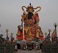
Posąg taoistycznego boga Xuantian Shangdi

Świątynia taoistyczna
Przypisy
- ↑ Lotus Pond. worldgames2009.tw. [dostęp 2011-01-05]. (ang.).
- ↑ 路線三:懷古文化之旅. gio.gov.tw. [dostęp 2010-12-31]. (chiń.).
- ↑ Andrew Bender, Julie Grundvig, Robert Kelly: Taiwan. London: Lonely Planet, 2004, s. 253. ISBN 978-1740593601.
- ↑ Water Ski. worldgames2009.tw. [dostęp 2010-12-29]. (ang.).
- ↑ Canoe Polo. worldgames2009.tw. [dostęp 2010-12-29]. (ang.).
- ↑ Dragon Boat (Invitational Sports). worldgames2009.tw. [dostęp 2010-12-29]. (ang.).
Media użyte na tej stronie


Legenda jezioro.gif
Autor: Tzugaj, Licencja: CC0
znak graficzny do map, ukazujący przykładowe jezioro
Autor: Tzugaj, Licencja: CC0
znak graficzny do map, ukazujący przykładowe jezioro

Kaohsiung IMG 2890.JPG
Autor: Benjiho, Licencja: CC BY-SA 3.0
Dragon and Tiger Pagodas at night, Zuoying, Kaohsiung, Taiwan.
Autor: Benjiho, Licencja: CC BY-SA 3.0
Dragon and Tiger Pagodas at night, Zuoying, Kaohsiung, Taiwan.
Kaohsiung Lianchitan ( WEI, WAN-CHEN ).jpg
Autor: WEI, WAN-CHEN(魏琬臻), Licencja: CC BY-SA 4.0
Lianchitan is located on the east side of Zuoying District of Kaohsiung City, adjacent to Guishan in the south and Banping Mountain in the north. The area of the pond is about 42 hectares, which originates from Gaoping River. Due to the lotus planting around the Lotus pond, it was one of the eight scenic spots in Fengshan during the Qing Dynasty. It is now known as the "Lintan Xizhao" because of the special shape of the Banping Mountain on the lakeside and the Dragon Tiger Tower. After entering the night , the lotus pond, the mist is misty, the scenery is looming, giving people an indescribable mystery.
Taiwan relief location map.jpg
Autor: Uwe Dedering, Licencja: CC BY-SA 3.0
Relief location map of Taiwan.
Autor: Uwe Dedering, Licencja: CC BY-SA 3.0
Relief location map of Taiwan.
- Projection: Equirectangular projection, strechted by 110.0%.
- Geographic limits of the map:
- N: 26.4° N
- S: 21.7° N
- W: 118.0° E
- E: 122.3° E
- GMT projection: -JX17.204266666666665cd/20.68512992248063cd
- GMT region: -R118.0/21.7/122.3/26.4r
- GMT region for grdcut: -R118.0/21.7/122.3/26.4r
- Relief: SRTM30plus.
- Made with Natural Earth. Free vector and raster map data @ naturalearthdata.com.

Kaohsiung IMG 2864.JPG
Autor: Benjiho, Licencja: CC BY-SA 3.0
Temple on Lotus Pond, Kaohsiung, Taiwan
Autor: Benjiho, Licencja: CC BY-SA 3.0
Temple on Lotus Pond, Kaohsiung, Taiwan

Kaohsiung IMG 2870.JPG
Autor: Benjiho, Licencja: CC BY-SA 3.0
Taoist temple by Lotus Pond, Zuoying, Kaohsiung, Taiwan.
Autor: Benjiho, Licencja: CC BY-SA 3.0
Taoist temple by Lotus Pond, Zuoying, Kaohsiung, Taiwan.