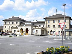
Lichtenfels (stacja kolejowa)
| ||
 | ||
| Państwo | ||
| Kraj związkowy | ||
| Miejscowość | Lichtenfels | |
| Data otwarcia | 1846 | |
| Dane techniczne | ||
| Liczba peronów | 4 | |
| Liczba krawędzi peronowych | 6 | |
| Kasy | czynne | |
| Linie kolejowe | ||
| ||
| Portal | ||
Lichtenfels – stacja kolejowa w Lichtenfels, w kraju związkowym Bawaria, w Niemczech. Znajdują się tu 4 perony.
| Lichtenfels | ||
| Linia Bamberg - Hof (31,9 km) | ||
odległość: 6,2 km | odległość: 34,2 km | |
Media użyte na tej stronie
Germany location map.svg
Autor: NordNordWest, Licencja: CC BY-SA 3.0
Location map of Germany (Wp article: en:Germany)
Autor: NordNordWest, Licencja: CC BY-SA 3.0
Location map of Germany (Wp article: en:Germany)
BSicon KBHFl.svg
head station, track to the left
head station, track to the left
BSicon KBHFaq.svg
head station, track to the left
head station, track to the left
BSicon STRq.svg
Straight line aqross (according to naming convention, name + modifier)
Straight line aqross (according to naming convention, name + modifier)
BSicon BHFq.svg
station at track aqross
station at track aqross
BSicon KBHFr.svg
head station, track to the right
head station, track to the right
BSicon KBHFeq.svg
head station, track to the right
head station, track to the right
Bavaria location map G.svg
Autor: Hanhil based upon previous work by TUBS, Licencja: CC BY-SA 3.0
Location map Bavaria, showing position of Bavaria within Germany. Geographic limits of the map:
Autor: Hanhil based upon previous work by TUBS, Licencja: CC BY-SA 3.0
Location map Bavaria, showing position of Bavaria within Germany. Geographic limits of the map:
Bf Lichtenfels.JPG
Autor: Michael Sander, Licencja: CC-BY-SA-3.0
Bahnhof von Lichtenfels (Bayern, Deutschland).
Autor: Michael Sander, Licencja: CC-BY-SA-3.0
Bahnhof von Lichtenfels (Bayern, Deutschland).


