Lija
 Jedna z uliczek w Lija | |||||
| |||||
| Państwo | |||||
|---|---|---|---|---|---|
| Kod ISO 3166-2 | MT-24[1] | ||||
| Burmistrz | Magda Magri Naudi | ||||
| Powierzchnia | 1,1 km²[2] | ||||
| Populacja (2014) • liczba ludności |
| ||||
| • gęstość | 2791 os./km² | ||||
| Kod pocztowy | LJA | ||||
Adres urzędu: 27, Robert Mifsud Bonnici StreetLija LJA 1403 Malta[4] | |||||
Położenie na mapie Malty | |||||
| 35°54′05″N 14°26′50″E/35,901389 14,447222 | |||||
Lija – jedna z jednostek administracyjnych na Malcie. Mieszka tutaj 3 070 osób[3]. Część Three Villages.
Turystyka
- Wieża Lija Belvedere (Lija Belvedere Tower), belweder z 1857 roku
- Villa Francia, palladianizmowy (z zewnątrz) i barokowy (wewnątrz) pałac zbudowany ok. 1757 roku
- Villa Parisio, willa z XVI wieku
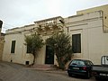
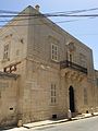
- Villa Gourgion, willa z XVIII wieku[5][6]
- Kościół Przemienienia Pańskiego (Our Saviour's Church) z 1700 roku, z późniejszymi rozbudowami
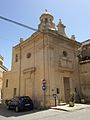
- Kościół św. Piotra (Church of Saint Peter)
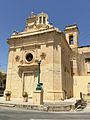
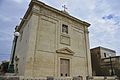
- Kościół Chrystusa Zbawiciela (Church of Christ the Saviour)
- Kościół św. Andrzeja (Church of Saint Andrew)
- Kościół Mariacki (Church of St. Mary)
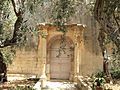
- Kościół Madonny tal-Mirakli (Church of the Madonna tal-Mirakli)
- Kościół Niepokalanego Poczęcia (Church of the Immaculate Conception)
- Jeden z ogrodów Ġonna tal-Kmand, znajduje przy Triq Annibale Preca[7], w obszarze znanym jako Tal-Mirakli w pobliżu granicy z Attard. Ten ogród został częściowo zbudowany jako Plant Biotechnology Center i jego laboratoria. Ma zbiorniki zasilające pobliski Pałac San Anton[8][9].
Lija Belvedere Tower
Villa Francia
Villa Parisio
Villa Gourgion

Kościół Przemienienia Pańskiego
Kościół św. Piotra
Kościół Chrystusa Zbawiciela

Kościół św. Andrzeja
Kościół Mariacki
Kościół Madonny tal-Mirakli
Sport
W miejscowości funkcjonuje klub piłkarski Lija Athletic FC. Powstał w 1949 roku. Obecnie gra w Maltese First Division, drugiej maltańskiej lidze.
Przypisy
- ↑ ISO 3166-2 MT - Międzynarodowa Organizacja Normalizacyjna, 2015
- ↑ Localities of Malta - statoids.com
- ↑ a b Estimated Population by Locality 31st March, 2014. gov.mt. (ang.).
- ↑ Lija local council
- ↑ Details. perry.com.mt. [zarchiwizowane z tego adresu (2017-05-06)]..
- ↑ Details. malta-relocation.com. [zarchiwizowane z tego adresu (2017-05-06)].
- ↑ No. 590 – Developing and Planning Act, 1992 (Section 46) – Scheduling of Property. Malta Government Gazette.
- ↑ The Malta Independent: Securing What's left of 'Gonna tal-Kmand'. [zarchiwizowane z tego adresu].
- ↑ Michael Ellul: History on Marble: A Corpus of Inscriptions in the Presidential Palaces in Valletta, San Anton and Verdala, Malta. 1998, s. 322. ISBN 978-99909-0-103-0.
| wyspa Malta Rady lokalne |
|
|---|---|
| wyspa Malta Komitety administracyjne |
|
| wyspa Gozo Rady lokalne | |
| wyspa Gozo Komitety administracyjne |

Media użyte na tej stronie

Coat of arms of Malta.svg
Coat of arms of Malta.
Coat of arms of Malta.
.jpg)
Church of Christ the Saviour (Old Church).jpg
Autor: Continentaleurope, Licencja: CC BY-SA 4.0
This media is about Maltese cultural property with inventory number 00812.
Autor: Continentaleurope, Licencja: CC BY-SA 4.0
This media is about Maltese cultural property with inventory number 00812.

Villa Francia, Villa Preziosi.jpeg
(c) Continentaleurope z angielskiej Wikipedii, CC BY-SA 3.0
Villa Francia, Villa Preziosi
(c) Continentaleurope z angielskiej Wikipedii, CC BY-SA 3.0
Villa Francia, Villa Preziosi
Lija in Malta.svg
Autor: TUBS
 ,
Licencja: CC BY-SA 3.0
,
Licencja: CC BY-SA 3.0
Location of local council XY (see filename) in Malta
Autor: TUBS
Location of local council XY (see filename) in Malta


Church of Saint Peter, Lija.jpg
Autor: Continentaleurope, Licencja: CC BY-SA 4.0
This media is about Maltese cultural property with inventory number 00809.
Autor: Continentaleurope, Licencja: CC BY-SA 4.0
This media is about Maltese cultural property with inventory number 00809.

Il-Kappella tal-Madonna tal-Mirakli.jpg
Autor: Cuci777, Licencja: CC BY-SA 4.0
This media is about Maltese cultural property with inventory number 00826.
Autor: Cuci777, Licencja: CC BY-SA 4.0
This media is about Maltese cultural property with inventory number 00826.


Church of St. Mary.jpg
Autor: Continentaleurope, Licencja: CC BY-SA 4.0
This media is about Maltese cultural property with inventory number 00814.
Autor: Continentaleurope, Licencja: CC BY-SA 4.0
This media is about Maltese cultural property with inventory number 00814.

Dar Karmen Grima.jpg
Autor: Continentaleurope, Licencja: CC BY-SA 4.0
This media is about Maltese cultural property with inventory number 01177.
Autor: Continentaleurope, Licencja: CC BY-SA 4.0
This media is about Maltese cultural property with inventory number 01177.

Church of Saint Andrew, Lija.jpg
Autor: Continentaleurope, Licencja: CC BY-SA 4.0
This media is about Maltese cultural property with inventory number 00813.
Autor: Continentaleurope, Licencja: CC BY-SA 4.0
This media is about Maltese cultural property with inventory number 00813.


Belvedere Tower n Lija Malta.jpeg
(c) Continentaleurope z angielskiej Wikipedii, CC BY-SA 3.0
Belvedere Tower n Lija Malta
(c) Continentaleurope z angielskiej Wikipedii, CC BY-SA 3.0
Belvedere Tower n Lija Malta