Linia 12 metra w Szanghaju
 | ||||||||||||||||||||||||||||||||||||||||||||||||||||||||||||||||||||||||||||||||||||||||||||||||||||||||||||||||||||||||||||||||||||||||||||||||||||||||||||||||||||||||||||||||||||||||||||||||||||
| Dane podstawowe | ||||||||||||||||||||||||||||||||||||||||||||||||||||||||||||||||||||||||||||||||||||||||||||||||||||||||||||||||||||||||||||||||||||||||||||||||||||||||||||||||||||||||||||||||||||||||||||||||||||
| Zarządca | Shanghai No.4 Metro Operation Co. Ltd. | |||||||||||||||||||||||||||||||||||||||||||||||||||||||||||||||||||||||||||||||||||||||||||||||||||||||||||||||||||||||||||||||||||||||||||||||||||||||||||||||||||||||||||||||||||||||||||||||||||
|---|---|---|---|---|---|---|---|---|---|---|---|---|---|---|---|---|---|---|---|---|---|---|---|---|---|---|---|---|---|---|---|---|---|---|---|---|---|---|---|---|---|---|---|---|---|---|---|---|---|---|---|---|---|---|---|---|---|---|---|---|---|---|---|---|---|---|---|---|---|---|---|---|---|---|---|---|---|---|---|---|---|---|---|---|---|---|---|---|---|---|---|---|---|---|---|---|---|---|---|---|---|---|---|---|---|---|---|---|---|---|---|---|---|---|---|---|---|---|---|---|---|---|---|---|---|---|---|---|---|---|---|---|---|---|---|---|---|---|---|---|---|---|---|---|---|---|---|---|---|---|---|---|---|---|---|---|---|---|---|---|---|---|---|---|---|---|---|---|---|---|---|---|---|---|---|---|---|---|---|---|---|---|---|---|---|---|---|---|---|---|---|---|---|---|---|---|
| Oznaczenie linii | 12 | |||||||||||||||||||||||||||||||||||||||||||||||||||||||||||||||||||||||||||||||||||||||||||||||||||||||||||||||||||||||||||||||||||||||||||||||||||||||||||||||||||||||||||||||||||||||||||||||||||
| Czas przejazdu | 77 min | |||||||||||||||||||||||||||||||||||||||||||||||||||||||||||||||||||||||||||||||||||||||||||||||||||||||||||||||||||||||||||||||||||||||||||||||||||||||||||||||||||||||||||||||||||||||||||||||||||
| Liczba stacji | 32 | |||||||||||||||||||||||||||||||||||||||||||||||||||||||||||||||||||||||||||||||||||||||||||||||||||||||||||||||||||||||||||||||||||||||||||||||||||||||||||||||||||||||||||||||||||||||||||||||||||
| Długość | 40,4 km | |||||||||||||||||||||||||||||||||||||||||||||||||||||||||||||||||||||||||||||||||||||||||||||||||||||||||||||||||||||||||||||||||||||||||||||||||||||||||||||||||||||||||||||||||||||||||||||||||||
| Rozstaw szyn | 1435 mm | |||||||||||||||||||||||||||||||||||||||||||||||||||||||||||||||||||||||||||||||||||||||||||||||||||||||||||||||||||||||||||||||||||||||||||||||||||||||||||||||||||||||||||||||||||||||||||||||||||
| Sieć trakcyjna | 1500 V | |||||||||||||||||||||||||||||||||||||||||||||||||||||||||||||||||||||||||||||||||||||||||||||||||||||||||||||||||||||||||||||||||||||||||||||||||||||||||||||||||||||||||||||||||||||||||||||||||||
 Stacja Dalian Road | ||||||||||||||||||||||||||||||||||||||||||||||||||||||||||||||||||||||||||||||||||||||||||||||||||||||||||||||||||||||||||||||||||||||||||||||||||||||||||||||||||||||||||||||||||||||||||||||||||||
| Historia | ||||||||||||||||||||||||||||||||||||||||||||||||||||||||||||||||||||||||||||||||||||||||||||||||||||||||||||||||||||||||||||||||||||||||||||||||||||||||||||||||||||||||||||||||||||||||||||||||||||
| Lata budowy | 2008 - 2015 | |||||||||||||||||||||||||||||||||||||||||||||||||||||||||||||||||||||||||||||||||||||||||||||||||||||||||||||||||||||||||||||||||||||||||||||||||||||||||||||||||||||||||||||||||||||||||||||||||||
| Rok otwarcia | 2013 | |||||||||||||||||||||||||||||||||||||||||||||||||||||||||||||||||||||||||||||||||||||||||||||||||||||||||||||||||||||||||||||||||||||||||||||||||||||||||||||||||||||||||||||||||||||||||||||||||||
| ||||||||||||||||||||||||||||||||||||||||||||||||||||||||||||||||||||||||||||||||||||||||||||||||||||||||||||||||||||||||||||||||||||||||||||||||||||||||||||||||||||||||||||||||||||||||||||||||||||
| Portal | ||||||||||||||||||||||||||||||||||||||||||||||||||||||||||||||||||||||||||||||||||||||||||||||||||||||||||||||||||||||||||||||||||||||||||||||||||||||||||||||||||||||||||||||||||||||||||||||||||||
Linia 12 metra w Szanghaju – przebiegająca z północnego wschodu na południowy zachód 12. linia szanghajskiego metra, biegnie przez 40,4 km od stacji stacji Jinhai Road w północnej części dzielnicy Pudong, przez rzekę Huangpu i centrum Szanghaju i Xuhui, do Qixin Road w dzielnicy Minhang. Jej pierwszy, około 12-kilometrowy północno-wschodni odcinek Jinhai Road – Tiantong Lu (ang. Tiantong Road) został otwarty 29 grudnia 2013 roku[1]. Następnie dwukrotnie linię wydłużano na południe i zachód: 10 maja 2014 r. przedłużono ją o jedną stację – Qufu Lu (ang. Qufu Road) – łącząc linię 12 z linią 8, zaś 19 grudnia 2015 r. oddano do użytku pozostałe 16 stacji[2]. Po tym wydłużeniu linia dwunasta miała najwięcej stacji przesiadkowych w całym szanghajskim metrze. W identyfikacji wizualnej linia ma kolor ciemnozielony.
Galeria
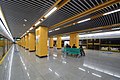
Peron linii 12 na stacji Qufu

Stacja końcowa Qizin
Przypisy
- ↑ Keith Barrow, Shanghai opens two more metro lines, „International Railway Journal”, 7 stycznia 2014 [dostęp 2018-01-06] (ang.).
- ↑ Zhang Ningniing, Metro network adds 27 stations, ShanghaiDaily.com, 18 grudnia 2015 [dostęp 2018-01-06] (ang.).
Linki zewnętrzne
- Rozkład jazdy linii 12 (ang.)
Media użyte na tej stronie


underground train station (legend icon)

ex underground train station (legend icon)


underground train stop (legend icon)

ex underground train stop (legend icon)


underground service station (legend icon)

ex underground service station (legend icon)

non-passenger stop (legend icon)

ex non-passenger stop (legend icon)

underground service stop (legend icon)

ex underground service stop (legend icon)


local-only minor station

Icons for railway description

out-of-use local-only minor metro station


Railroad BSicon


Underground straight track

ex underground straight track


straight line, modified version (+ex, +t, +ext)

underground tunnel straight track

ex underground tunnel straight track

high level track

ex high level track

underground high level track

ex underground high level track

Bridge (big)

Bridge (big)


BS template transport icon

bridge over water straight (big)

bridge over water straight (big)


for BS models. water tunnel, urban(blue), not in use.

mileage change

ex mileage change

A mile-marker for metros/canals

mileage change


Border icon

Track change (new design)

track change (new design)

Track switch, metro/light rail

track change, metro/light rail (new design)

level crossing straight

Disused railway line level crossing on minor road.

underground level crossing straight

Ex underground level crossing straight


Autor: Lekko gazowany, Licencja: CC BY-SA 3.0
electrified line start sign for railways


Autor: Lekko gazowany, Licencja: CC BY-SA 3.0
electrified line end sign for railways

Icons for railway description

underground non-passenger station


underground stop

Pfeil nach rechts


underground station aqross

Autor: Baycrest, Licencja: CC BY-SA 2.5
Line 12 Platform of Qixin Road Station, Shanghai Metro

Autor: Baycrest, Licencja: CC BY-SA 2.5
Line 12 Platform of Qufu Road Station, Shanghai Metro

Underground crossing overhead


Underground station

Underground crossing underneath


Shanghai Metro Line 12 Logo
