Müllrose
| |||
 | |||
| |||
| Państwo | |||
| Kraj związkowy | Brandenburgia | ||
| Burmistrz | Ingomar Friebel | ||
| Powierzchnia | 68,54 km² | ||
| Wysokość | 42 m n.p.m. | ||
| Populacja (31 grudnia 2014) • liczba ludności • gęstość | 4 514 65 os./km² | ||
| Nr kierunkowy | 033606 | ||
| Kod pocztowy | 15299 | ||
| Tablice rejestracyjne | LOS, BSK, EH, FW | ||
 | |||
Położenie na mapie Brandenburgii  | |||
Położenie na mapie Niemiec  | |||
| Strona internetowa | |||
| Portal | |||
Müllrose (dolnołuż. Miłoraz, pol. hist. Miłoradz[1]) − miasto w Niemczech, w kraju związkowym Brandenburgia, w powiecie Oder-Spree, siedziba Związku Gmin Schlaubetal. Według danych z 31 grudnia 2008 miasto liczyło 4 504 mieszkańców. Jest miejscowością partnerską polskiej gminy Słońsk oraz pogranicznym miastem historycznej ziemi lubuskiej.
Historia
W 1275 miejscowość została po raz pierwszy wspomniana pod nazwą Molrasen. W latach 1373-1415 wraz z Marchią Brandenburską znajdowała się pod panowaniem Królestwa Czech. Od 1701 miasto leżało w granicach Królestwa Prus, które w 1871 zostało częścią zjednoczonych Niemiec. W latach 1949-1990 miasto było częścią NRD.
Demografia
|
|
|
|
Galeria

Dworzec kolejowy
Młyn
Plaża nad jeziorem
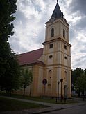
Kościół luterański
Ratusz

Remiza

Dawne sanatorium

Apteka
Dom przy ul. Bezkowskiej (Beeskower Straße)

Kamienica przy Rynku
Przypisy

Media użyte na tej stronie
Autor: Hanhil based on work by NordNordWest, Licencja: CC BY-SA 3.0
Location map of Brandenburg, showing position of Brandenburg within Germany
Autor: NordNordWest, Licencja: CC BY-SA 3.0
Location map of Germany (Wp article: en:Germany)

![[1]](https://web.archive.org/web/20160304091731/http://www.mapywig.org/m/WIG_maps/series/500K_post-WW2/MAPA_POLSKI_1_500_000_LEGNICA_5.jpg)

Autor: Lienhard Schulz, Licencja: CC BY-SA 3.0
Fischerstraße (german for: fishers street) in Müllrose, a town in the District Oder-Spree, Brandenburg, Germany.


Autor: Oberlausitzerin64, Licencja: CC BY-SA 4.0
Gut Zeisigberg - ehemalige Lungenheilanstalt in Müllrose
Autor: own work by Geograv, Licencja: CC-BY-SA-3.0
Müllrose in Brandenburg (Country) - District Oder-Spree


Autor: J.Rzadkowski, Licencja: CC BY-SA 3.0 de
Müllrose, ehemaliges Wohnhaus der Müller - Familie Többicke, heute Apotheke

Autor: Lienhard Schulz, Licencja: CC BY-SA 3.0
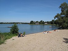
Beach at the eastern bank of the Großer Müllroser See. The lake is situated between the town Müllrose in the north and the municipality Mixdorf in the south in the District Oder-Spree, Brandenburg, Germany. The lake covers 1,32 km² and is a part of the Schlaube Valley Nature Park.


Autor: Lienhard Schulz, Licencja: CC BY-SA 3.0
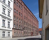
Brick facade of the Mühle Müllrose. The watermill was first mentioned in a document in 1275 and is still in use today. The mill is situated at the Großer Müllroser See (lake) in Müllrose, a town in the District Oder-Spree, Brandenburg, Germany.