Marktheidenfeld
 | |||
| |||
| Państwo | |||
|---|---|---|---|
| Kraj związkowy | Bawaria | ||
| Rejencja | Dolna Frankonia | ||
| Powiat | Main-Spessart | ||
| Kod statystyczny | 09 6 77 157 | ||
| Powierzchnia | 37,54 km² | ||
| Wysokość | 140-355 m n.p.m. | ||
| Populacja (31 grudnia 2011) • liczba ludności • gęstość | 10 867 289 os./km² | ||
| Nr kierunkowy | 09391 | ||
| Kod pocztowy | 97828 | ||
| Tablice rejestracyjne | MSP | ||
 | |||
| Strona internetowa | |||
| Portal | |||
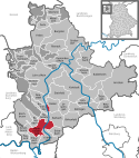
Marktheidenfeld – miasto w Niemczech, w kraju związkowym Bawaria, w rejencji Dolna Frankonia, w regionie Würzburg, w powiecie Main-Spessart, siedziba wspólnoty administracyjnej Marktheidenfeld, do której jednak miasto nie należy. Leży ok. 17 km na południowy zachód od Karlstadt, nad Menem, przy autostradzie A3, drodze B8 i byłej linii kolejowej Lohr am Main - Würzburg.
Dzielnice
W skład miasta wchodzą następujące dzielnice:
- Altfeld
- Glasofen (z osiedlem: Eichenfürst)
- Marienbrunn
- Marktheidenfeld (z osiedlem: Haunermühle)
- Michelrieth
- Oberwittbach
- Zimmern
Demografia
| Rok | Liczba mieszk. |
| 1920 | 2 058 |
| 1938 | 2 687 |
| 1946 | 4 302 |
| 1970 | 8 364 |
| 1987 | 9 421 |
| 2000 | 10 803 |
Polityka
Burmistrzem jest Helga Schmidt-Neder z WW. Rada miasta:
| CSU | SPD | Zieloni | Wolni Wyborcy | Razem | |
| 2002 | 10 | 5 | 1 | 8 | 24 miejsc |
| 2008 | 9 | 5 | 1 | 9 | 24 miejsc |
| 2014 | 9 | 5 | 0 | 10 | 24 miejsc |
Współpraca
Miejscowości partnerskie:
 Germantown, Stany Zjednoczone (od 1980)
 Montfort-sur-Meu, Francja (od 1988)
 Taidong, Republika Chińska (od 1985)
 Pobiedziska, Polska (od 2007)
Osoby urodzone w Marktheidenfeldzie
- Friedrich Fleischmann (1766-1798), kompozotor
- René Frank (ur. 1974), kompozytor i pisarz
- Tanja Hart (ur. 1974), siatkarka
- Tina Landgraf (ur. 1976), aktorka telewizyjna
- Regina Schleicher (ur. 1974); kolarka
Media użyte na tej stronie
Autor: Hanhil based upon previous work by TUBS, Licencja: CC BY-SA 3.0
Location map Bavaria, showing position of Bavaria within Germany. Geographic limits of the map:
Autor: NordNordWest, Licencja: CC BY-SA 3.0
Location map of Germany (Wp article: en:Germany)
The flag of Navassa Island is simply the United States flag. It does not have a "local" flag or "unofficial" flag; it is an uninhabited island. The version with a profile view was based on Flags of the World and as a fictional design has no status warranting a place on any Wiki. It was made up by a random person with no connection to the island, it has never flown on the island, and it has never received any sort of recognition or validation by any authority. The person quoted on that page has no authority to bestow a flag, "unofficial" or otherwise, on the island.
|
|
|
|
|
|
|
|
Autor:
Ja, właściciel praw autorskich do tego dzieła, udostępniam je na poniższej licencji
Autor: Dr. Reiner Düren aka RedPiranha, Licencja: CC BY-SA 3.0 de
Marktheidenfeld (Blick von der alten Mainbrücke)


