Massachusetts (zatoka)
| ||
 Zatoka widziana z Beverly (Massachusetts) | ||
| Państwo | ||
| Stan | ||
| Lokalizacja | Ocean Atlantycki | |
| Wymiary | 68 × 34 km | |
| Miejscowości nadbrzeżne | Boston | |
 | ||
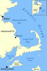
Zatoka Massachusetts (ang. Massachusetts Bay) – jedna z większych zatok na amerykańskim wybrzeżu Oceanu Atlantyckiego. Zatoka dzieli się na kilka mniejszych, m.in. Quincy, Dorchester i Boston Harbor. Głównym miastem i portem jest Boston.
Media użyte na tej stronie
Autor: Alexrk2, Licencja: CC BY 3.0
Location map of Massachusetts, USA
Autor: Uwe Dedering, Licencja: CC BY-SA 3.0
Relief location map of the USA (without Hawaii and Alaska).
EquiDistantConicProjection : Central parallel :
* N: 37.0° N
Central meridian :
* E: 96.0° W
Standard parallels:
* 1: 32.0° N
* 2: 42.0° N
Made with Natural Earth. Free vector and raster map data @ naturalearthdata.com.
Formulas for x and y:
x = 50.0 + 124.03149777329222 * ((1.9694462586094064-({{{2}}}* pi / 180))
      * sin(0.6010514667026994 * ({{{3}}} + 96) * pi / 180))
y = 50.0 + 1.6155950752393982 * 124.03149777329222 * 0.02613325650382181
      - 1.6155950752393982  * 124.03149777329222 *
     (1.3236744353715044  - (1.9694462586094064-({{{2}}}* pi / 180))
      * cos(0.6010514667026994 * ({{{3}}} + 96) * pi / 180))
The flag of Navassa Island is simply the United States flag. It does not have a "local" flag or "unofficial" flag; it is an uninhabited island. The version with a profile view was based on Flags of the World and as a fictional design has no status warranting a place on any Wiki. It was made up by a random person with no connection to the island, it has never flown on the island, and it has never received any sort of recognition or validation by any authority. The person quoted on that page has no authority to bestow a flag, "unofficial" or otherwise, on the island.
Autor: Autor nie został podany w rozpoznawalny automatycznie sposób. Założono, że to NormanEinstein (w oparciu o szablon praw autorskich)., Licencja: CC-BY-SA-3.0
Map showing the location of Cape Cod Bay and Massachusetts Bay, off the west coast of Massachusetts, United States.
Created by NormanEinstein, July 20, 2005.Autor: John Phelan, Licencja: CC BY 3.0
View of Massachusetts Bay from Mingo Beach, Endicott College, Beverly Massachusetts


