Menston
 | |
| Państwo | |
|---|---|
| Kraj | |
| Hrabstwo | |
| Dystrykt | |
| Populacja (2001) • liczba ludności |
|
| Nr kierunkowy | 01943 |
| Kod pocztowy | LS29 |
Położenie na mapie West Yorkshire  Contains Ordnance Survey data © Crown copyright and database right, CC BY-SA 3.0 | |
Położenie na mapie Wielkiej Brytanii  (c) Karte: NordNordWest, Lizenz: Creative Commons by-sa-3.0 de | |
Położenie na mapie Anglii  | |
| Strona internetowa | |
| Portal | |
Menston – wieś oraz civil parish w Wielkiej Brytanii, w Anglii, w regionie Yorkshire and the Humber, w hrabstwie West Yorkshire, w dystrykcie Bradford. W 2001 miejscowość liczyła 4660 mieszkańców[1].
Galeria zdjęć
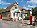
Urząd Pocztowy w Menston
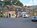
Sklepy na skrzyżowaniu Main Street i Burley Lane
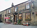
Pub The Malt Shovel

Pub Menston Arms
Przypisy
- ↑ KS01 Usual resident population: Census 2001, Key Statistics for urban areas (ang.). Office for National Statistics. [dostęp 2016-12-02]. [zarchiwizowane z tego adresu (2004-07-23)].
Media użyte na tej stronie
United Kingdom adm location map.svg
(c) Karte: NordNordWest, Lizenz: Creative Commons by-sa-3.0 de
Location map of the United Kingdom
(c) Karte: NordNordWest, Lizenz: Creative Commons by-sa-3.0 de
Location map of the United Kingdom


Flag of England.svg
Flag of England. Saint George's cross (a red cross on a white background), used as the Flag of England, the Italian city of Genoa and various other places.
Flag of England. Saint George's cross (a red cross on a white background), used as the Flag of England, the Italian city of Genoa and various other places.

Menston Arms.jpg
Autor: Mtaylor848, Licencja: CC BY-SA 3.0
The Menston Arms public house, Main Street, Menston, West Yorkshire. Taken on the afternoon of Saturday 22nd August 2009.
Autor: Mtaylor848, Licencja: CC BY-SA 3.0
The Menston Arms public house, Main Street, Menston, West Yorkshire. Taken on the afternoon of Saturday 22nd August 2009.

Menston Post Office.jpg
Autor: Mtaylor848, Licencja: CC BY-SA 3.0
Menston Post Office, Main Street, Menston, West Yorkshire. Taken on the afternoon of Saturday 22nd August 2009.
Autor: Mtaylor848, Licencja: CC BY-SA 3.0
Menston Post Office, Main Street, Menston, West Yorkshire. Taken on the afternoon of Saturday 22nd August 2009.

Malt Shovel, Menston.jpg
Autor: Mtaylor848, Licencja: CC BY-SA 3.0
The Malt Shovel public house, Main Street, Menston, West Yorkshire. Taken on the afternoon of Saturday 22nd August 2009.
Autor: Mtaylor848, Licencja: CC BY-SA 3.0
The Malt Shovel public house, Main Street, Menston, West Yorkshire. Taken on the afternoon of Saturday 22nd August 2009.
West Yorkshire UK location map.svg
Contains Ordnance Survey data © Crown copyright and database right, CC BY-SA 3.0
Contains Ordnance Survey data © Crown copyright and database right, CC BY-SA 3.0
Map of West Yorkshire, UK with the following information shown:
- Administrative borders
- Coastline, lakes and rivers
- Roads and railways
- Urban areas
Equirectangular map projection on WGS 84 datum, with N/S stretched 170%
Geographic limits:
- West: 2.30W
- East: 1.18W
- North: 53.98N
- South: 53.50N

Shops in Menston1.jpg
Autor: Mtaylor848, Licencja: CC BY-SA 3.0
Shops on the junction of Main Street and Burley Lane (to the North side of Main Street and the East side of Burley Lane) in Menston, West Yorkshire. Taken on the afternoon of Saturday 22nd August 2009.
Autor: Mtaylor848, Licencja: CC BY-SA 3.0
Shops on the junction of Main Street and Burley Lane (to the North side of Main Street and the East side of Burley Lane) in Menston, West Yorkshire. Taken on the afternoon of Saturday 22nd August 2009.
Main Street, Menston.jpg
Autor: Mtaylor848, Licencja: CC BY-SA 3.0
Main Street, Menston, West Yorkshire looking West. The photograph was taken on the afternoon of Saturday 22nd August 2009.
Autor: Mtaylor848, Licencja: CC BY-SA 3.0
Main Street, Menston, West Yorkshire looking West. The photograph was taken on the afternoon of Saturday 22nd August 2009.