Merthyr Tydfil (hrabstwo miejskie)
| hrabstwo miejskie | |||
(c) Jaggery, CC BY-SA 2.0 Merthyr Tydfil | |||
| |||
| Państwo | |||
|---|---|---|---|
| Księstwo | |||
| Siedziba | |||
| Powierzchnia | 111 km² | ||
| Populacja • liczba ludności |
| ||
| • gęstość | 496 os./km² | ||
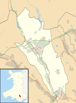
Położenie na mapie Walii | |||
| Strona internetowa | |||
| Portal | |||
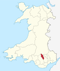
Merthyr Tydfil – hrabstwo miejskie w Walii. Od wschodu graniczy z hrabstwem Caerphilly, od zachodu z Rhondda Cynon Taf a od północy z Powys. W 2011 roku hrabstwo liczyło 58 802 mieszkańców[1][2].
Podział administracyjny
Communities (civil parishes)
- Bedlinog, Cyfarthfa, Dowlais, Gurnos, Merthyr Vale, Pant, Park, Penydarren, Town, Troed-y-Rhiw, Treharris i Vaynor.
Okręgi wyborcze (wards)
- Bedlinog, Cyfarthfa, Dowlais, Gurnos, Merthyr Vale, Park, Penydarren, Plymouth, Town, Treharris i Vaynor[3].
Miejscowości
Na terenie hrabstwa znajdują się następujące miejscowości[4][5] (w nawiasach liczba ludności w 2011[6]):
- Merthyr Tydfil (43 820)
- Treharris (7705)
- Aberfan (3547)
- Bedlinog (1112)
- Trefechan (1042)
Przypisy
- ↑ Area: Merthyr Tydfil (Local Authority). Neighbourhood Statistics (ONS). [dostęp 2016-10-29]. [zarchiwizowane z tego adresu (2016-10-29)]. (ang.).
- ↑ Merthyr Tydfil, [w:] Encyclopædia Britannica [online] [dostęp 2016-10-29] (ang.).
- ↑ Merthyr Tudful - Merthyr Tydfil. Ordnance Survey linked data. [dostęp 2016-10-29]. (ang.).
- ↑ Office for National Statistics: Built-up Area to Local Authority District (December 2011) Lookup in England and Wales. [w:] Open Geography Portal [on-line]. [dostęp 2022-06-05]. (ang.).
- ↑ Office for National Statistics: Built-up Area Sub Divisions (December 2011) Boundaries. [w:] Open Geography Potal [on-line]. [dostęp 2022-06-05]. (ang.).
- ↑ Office for National Statistics: KS101EW - Usual resident population. [w:] 2011 Census [on-line]. Nomis – Official labour market statistics, 2013-02-12. [dostęp 2022-06-05]. (ang.).
Media użyte na tej stronie
Autor: TUBS
Location of unitary authority area Merthyr Tydfil in Wales in Wales.
Contains Ordnance Survey data © Crown copyright and database right, CC BY-SA 3.0
Blank map of Merthyr Tydfil County Borough, UK with the following information shown:
- Administrative borders
- Coastline, lakes and rivers
- Roads and railways
- Urban areas
Equirectangular map projection on WGS 84 datum, with N/S stretched 160%
Geographic limits:
- West: 3.50W
- East: 3.25W
- North: 51.85N
- South: 51.64N
(c) Jaggery, CC BY-SA 2.0
Celtic Cross memorial, Merthyr Tydfil
This is not the town's main war memorial, but a Celtic Cross on the north side of Castle Street.
The inscription on the base is from For the Fallen by Laurence Binyon.
They shall grow not old, as we that are left grow old. Age shall not weary them, nor the years contemn. At the going down of the sun and in the morning
We will remember them.


