Morton (Carlisle)
(c) Rose and Trev Clough, CC BY-SA 2.0 | |
| Państwo | |
|---|---|
| Kraj | |
| Hrabstwo | |
| Dystrykt | |
| Populacja (2011) • liczba ludności |
|
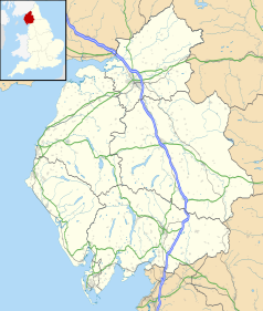
Położenie na mapie Kumbrii Contains Ordnance Survey data © Crown copyright and database right, CC BY-SA 3.0 | |
Położenie na mapie Wielkiej Brytanii (c) Karte: NordNordWest, Lizenz: Creative Commons by-sa-3.0 de | |
| 54°52′54,4″N 2°57′40,4″W/54,881778 -2,961222 | |
| Portal | |
Morton – dzielnica w Carlisle, w Anglii, w Kumbrii, w dystrykcie Carlisle[1]. W 2011 dzielnica liczyła 5825 mieszkańców[2].
Przypisy
- ↑ Ordnance Survey linked data. [dostęp 2015-10-30]. [zarchiwizowane z tego adresu (2012-09-05)].
- ↑ Neighbourhood Statistics. [dostęp 2015-10-30]. [zarchiwizowane z tego adresu (2016-03-04)].
Media użyte na tej stronie
Contains Ordnance Survey data © Crown copyright and database right, CC BY-SA 3.0
Map of Cumbria, UK with the following information shown:
- Administrative borders
- Coastline, lakes and rivers
- Roads and railways
- Urban areas
Equirectangular map projection on WGS 84 datum, with N/S stretched 170%
Geographic limits:
- West: 3.80W
- East: 2.10W
- North: 55.20N
- South: 54.02N
(c) Karte: NordNordWest, Lizenz: Creative Commons by-sa-3.0 de
Location map of the United Kingdom
Flag of England. Saint George's cross (a red cross on a white background), used as the Flag of England, the Italian city of Genoa and various other places.
(c) Rose and Trev Clough, CC BY-SA 2.0
Morton Manor An early 19th century building, which has been used as the Morton Community Centre since 1967. The house and surrounding park were given to the people of Carlisle by Sir Robert Chance, whose family lived there for many years. He was an industrialist and prominent citizen who died in 1960. In front of the house is a ha-ha, a ditch built to keep grazing animals out of the garden.


