Moundville (stanowisko archeologiczne)
 (c) Jeffrey Reed, CC BY-SA 3.0 Widok na stanowisko | |
| Państwo | |
|---|---|
Położenie na mapie Alabamy  | |
Położenie na mapie Stanów Zjednoczonych  | |
Moundville – stanowisko archeologiczne położone niedaleko miejscowości Moundville w zachodniej części amerykańskiego stanu Alabama[2]. Posiada status National Historic Landmark[3].
Stanowisko zajmuje obszar ok. 120 hektarów[2][4]. Zamieszkane w okresie od ok. 1050 do ok. 1450 roku przez ludność kultury Missisipi, stanowiło polityczny i ceremonialny ośrodek grupy osiedli istniejących w dolinie rzeki Black Warrior[3]. W okresie największego rozkwitu, przypadającego po 1250 roku, zamieszkiwało je ok. 3000 osób[4]. Na stanowisku znajduje się ponad 20 kopców ziemnych, na szczytach których znajdowały się dawniej budowle publiczne[3]. Największy kopiec, będący platformą dla świątyni, ma 18 m wysokości i 2 akry powierzchni[2]. Cała grupa kopców otoczona była drewnianą palisadą, poza obrębem której znajdowały się domostwa[3]. Po 1450 roku osada podupadła, w momencie przybycia pierwszych Europejczyków w XVI wieku była już całkowicie opustoszała[3].
W 1859 roku Nathaniel Lupton sporządził pierwszą mapę stanowiska. Badania archeologiczne przeprowadził w latach 1905-1906 Clarence B. Moore, a następnie między 1930-1941 grupa archeologów pracująca na zlecenie Alabama Museum of Natural History pod kierownictwem Davida de Jarnette i Maurice Goldsmitha. Na mniejszą skalę prace wykopaliskowe kontynuowano po II wojnie światowej[3]. Moundville zamieszkiwała ludność rolnicza, uprawiająca kukurydzę, fasolę i dynię. Oprócz tego zajmowano się zbieractwem, rybołówstwem i łowiectwem[3]. Materiał archeologiczny obejmuje wyroby kamienne i miedziane, muszle morskie i zdobioną ceramikę. Na stanowisku odkryto ponad 3 tysiące pochówków, z których część zawierała bogate wyposażenie grobowe[3].
Galeria
 (c) Jeffrey Reed, CC BY-SA 3.0
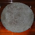
Kamienna paleta ozdobiona rytami
 (c) Herb Roe, CC BY-SA 3.0
Przykład ceramiki z Moundville
 (c) Jeffrey Reed, CC BY-SA 3.0
Jeden z kopców

Szkic stanowiska z okresu największej świetności
Przypisy
- ↑ Moundville. National Park Service. [dostęp 2015-10-11]. (ang.).
- ↑ a b c Moundville Archaeological Park, [w:] Encyclopædia Britannica [online] [dostęp 2015-10-11] (ang.).
- ↑ a b c d e f g h Archaeology in America. T. 1. Westport: Greenwood Publishing, 2009, s. 302-305. ISBN 978-0-313-33185-5.
- ↑ a b Wielka Historia Świata. T. 3. Kraków: Oficyna Wydawnicza Fogra, 2005, s. 730. ISBN 83-85719-84-9.
Media użyte na tej stronie
Autor: Uwe Dedering, Licencja: CC BY-SA 3.0
Location map of the USA (without Hawaii and Alaska).
EquiDistantConicProjection:
Central parallel:
* N: 37.0° N
Central meridian:
* E: 96.0° W
Standard parallels:
* 1: 32.0° N
* 2: 42.0° N
Made with Natural Earth. Free vector and raster map data @ naturalearthdata.com.
Formulas for x and y:
x = 50.0 + 124.03149777329222 * ((1.9694462586094064-({{{2}}}* pi / 180))
      * sin(0.6010514667026994 * ({{{3}}} + 96) * pi / 180))
y = 50.0 + 1.6155950752393982 * 124.03149777329222 * 0.02613325650382181
      - 1.6155950752393982  * 124.03149777329222 *
     (1.3236744353715044  - (1.9694462586094064-({{{2}}}* pi / 180))
      * cos(0.6010514667026994 * ({{{3}}} + 96) * pi / 180))

Blue Shield - the Distinctive emblem for the Protection of Cultural Property. The distinctive emblem is a protective symbol used during armed conflicts. Its use is restricted under international law.

The flag of Navassa Island is simply the United States flag. It does not have a "local" flag or "unofficial" flag; it is an uninhabited island. The version with a profile view was based on Flags of the World and as a fictional design has no status warranting a place on any Wiki. It was made up by a random person with no connection to the island, it has never flown on the island, and it has never received any sort of recognition or validation by any authority. The person quoted on that page has no authority to bestow a flag, "unofficial" or otherwise, on the island.

Symbol pomnika do legendy mapy
Autor: Alexrk2, Licencja: CC BY 3.0
Ta mapa została stworzona za pomocą GeoTools.

(c) Herb Roe, CC BY-SA 3.0
A photo of exotic(non-locally produced) pottery found at the Moundville Archaeological Site.

Autor: Aumich, Licencja: CC BY-SA 3.0
Sketch of Moundville site as it may have appeared at its height of occupation.

(c) Jeffrey Reed, CC BY-SA 3.0
The Rattlesnake Disk. A ceremonial stone palette plowed up by a 19th century farmer in Moundville, Hale County, Alabama, United States. Housed in the Jones Archaeological Museum at the Moundville Archaeological Park.
(c) Jeffrey Reed, CC BY-SA 3.0
Partial view of the plaza and surrounding mounds, with Mound A in the foreground, from the top of Mound B at the Moundville Archaeological Park in Moundville, Hale County, Alabama, United States.

(c) Jeffrey Reed, CC BY-SA 3.0
Mound B at the Moundville Archaeological Park in Moundville, Hale County, Alabama, United States.