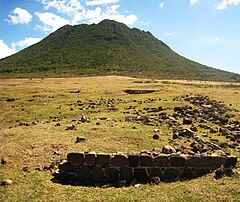
Mount Mazinga
| ||
 | ||
| Państwo | ||
| Gmina specjalna | ||
| Położenie | Sint Eustatius | |
| Wysokość | 601[1] m n.p.m. | |
Mount Mazinga – najwyższe wzniesienie Sint Eustatius – holenderskiej gminy zamorskiej na Karaibach. Wysokość – 601 metrów n.p.m. Jest położone w południowo-wschodniej części wyspy[1].
Przypisy
Bibliografia
- Saint Eustatius (ang.). WorldAtlas.
Media użyte na tej stronie
Black up-pointing triangle ▲, U+25B2 from Unicode-Block Geometric Shapes (25A0–25FF)
Autor: Walter Hellebrand, Licencja: CC BY-SA 3.0
The Quill dormant volcano on St. Eustatius seen from the remains of Battery St. Louis
Autor: Uwe Dedering, Licencja: CC BY-SA 3.0
Relief location map of Atlantic_Ocean.
- Projection: Lambert azimuthal equal-area projection.
- Area of interest:
- N: 70.0° N
- S: -70.0° N
- W: -95.0° E
- E: 25.0° E
- Projection center:
- NS: 0.0° N
- WE: -35.0° E
- GMT projection: -JA-35.0/0.0/180/19.998266666666666c
- GMT region: -R-147.58842045747764/-48.58942183011819/77.58842045747762/48.589421830118205r
- GMT region for grdcut: -R-148.0/-76.0/78.0/76.0r
- Relief: SRTM30plus.
- Made with Natural Earth. Free vector and raster map data @ naturalearthdata.com.


