Naha
| |||||||||
| |||||||||
 | |||||||||
| Państwo | |||||||||
|---|---|---|---|---|---|---|---|---|---|
| Prefektura | |||||||||
| Wyspa | |||||||||
| Region | |||||||||
| Burmistrz | Mikiko Shiroma | ||||||||
| Powierzchnia | 38,99 km² | ||||||||
| Populacja (2009) • liczba ludności • gęstość |
| ||||||||
| Kod pocztowy | 900-8585 | ||||||||
| Symbole japońskie | |||||||||
| Kwiat | |||||||||
Położenie na mapie prefektury Okinawa  | |||||||||
Położenie na mapie Japonii  | |||||||||
| Strona internetowa | |||||||||
| Portal | |||||||||
Naha (jap. 那覇市 Naha-shi) – miasto w Japonii, ośrodek administracyjny prefektury Okinawa, w południowej części wyspy Okinawa (należącej do archipelagu Riukiu), port handlowy i rybacki nad Morzem Wschodniochińskim[2].
Naha (ponad 300 tys. mieszkańców) to stolica i największe miasto prefektury Okinawa. Dzięki portowi i lotnisku pełni funkcję regionalnego węzła komunikacyjnego, oferując bezpośrednie połączenia lotnicze i promowe z innymi częściami Okinawy, Japonii i Azji.
W mieście rozwinął się przemysł włókienniczy, spożywczy oraz ceramiczny[1].
Galeria
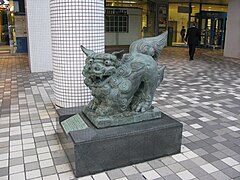
Shīsā (jęz. okinawski: shiisaa), stwór z mitologii okinawskiej, pochodzący od chińskich lwów-strażników

Kokusai-dōri (Aleja Międzynarodowa)

Zamek Shuri

Jedna z głównych ulic miasta
Miasta partnerskie
Przypisy
- ↑ a b Naha, [w:] Encyklopedia PWN [online] [dostęp 2021-07-28].
- ↑ 日本地図. Tokyo: Seibido Shuppan, 2018, s. 236, 237. ISBN 978-4-415-11272-5.
Media użyte na tej stronie
Autor: Maximilian Dörrbecker (Chumwa), Licencja: CC BY-SA 3.0
Location map of Japan
Equirectangular projection.
Geographic limits to locate objects in the main map with the main islands:
- N: 45°51'37" N (45.86°N)
- S: 30°01'13" N (30.02°N)
- W: 128°14'24" E (128.24°E)
- E: 149°16'13" E (149.27°E)
Geographic limits to locate objects in the side map with the Ryukyu Islands:
- N: 39°32'25" N (39.54°N)
- S: 23°42'36" N (23.71°N)
- W: 110°25'49" E (110.43°E)
- E: 131°26'25" E (131.44°E)


The flag of Navassa Island is simply the United States flag. It does not have a "local" flag or "unofficial" flag; it is an uninhabited island. The version with a profile view was based on Flags of the World and as a fictional design has no status warranting a place on any Wiki. It was made up by a random person with no connection to the island, it has never flown on the island, and it has never received any sort of recognition or validation by any authority. The person quoted on that page has no authority to bestow a flag, "unofficial" or otherwise, on the island.


Flag of Naha, Okinawa
.jpg)
The (male) shisha at the front of Mitsukoshi department store near the Kokusai doori in Naha, Okinawa, Japan.

Autor: Kugel, Licencja: CC BY-SA 3.0
The streetscape of Japan National Route 58 in Naha City.
Autor: Jackopoid, Licencja: CC-BY-SA-3.0
Topographic N20.0-35.0, E120.0-135.0
Autor: 663highland, Licencja: CC BY 2.5
Kokusai-dori (Kokusai street), Naha, Okinawa prefecture, Japan

Emblem of Naha

Autor: 663highland, Licencja: CC BY 2.5
Shuri Castle in Naha, Okinawa prefecture, Japan It was registered as part of the UNESCO World Heritage Site "Gusuku Sites and Related Properties of the Kingdom of Ryukyu".

Autor: Created by LERK, Licencja: Copyrighted free use
The shadow picture of Okinawa Prefecture (periphery of the Okinawa Island), Japan

Autor: 663highland, Licencja: CC BY 2.5
Kokusai-dori (Kokusai street), Naha, Okinawa prefecture, Japan
