Niż Islandzki
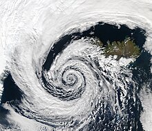
Niż Islandzki – klimatyczny niż baryczny z centrum między Islandią a Grenlandią. W zimie występuje także nad Morzem Barentsa.
Znaczenie Niżu Islandzkiego
Niż Islandzki występuje klimatycznie (czyli prawie cały czas) koło Islandii i jego intensywność wpływa na warunki pogodowe w Europie i obszarach polarnych. Dość często rozważany jest w kombinacji z Wyżem Azorskim (oscylacja północnoatlantycka).
Jednym z przykładów wpływu intensywności Niżu Islandzkiego na klimat i pogodę jest pokrywa lodu w Arktyce. Na rysunku pokazane są trzy mapy. Po lewej stronie jest mapa pokazująca dziewięć rozważanych obszarów. Po prawej dwie mapy ilustrują zmianę pokrywy lodu. Białym kolorem są zaznaczone obszary, gdy pokrywa lodu wzrastała, a niebieskim obszary, gdy pokrywa lodu malała. Pierwsza mapa pokazuje okres od 1979 do 1990, kiedy indeks NAO wzrastał – związane jest to ze wzrostem pokrywy lodu na zachód od Islandii (spływ zimnego powietrza z północy). Druga mapa dotyczy okresu od 1990 do 1999, kiedy pokrywa lodu na północny wschód od Islandii malała w związku z transportem cieplejszego powietrza.
Media użyte na tej stronie
A beautifully-formed low-pressure system swirls off the southwestern coast of Iceland, illustrating the maxim that "nature abhors a vacuum." The vacuum in this case would be a region of low atmospheric pressure. In order to fill this void, air from a nearby high-pressure system moves in, in this case bringing clouds along for the ride. And because this low-pressure system occurred in the Northern Hemisphere, the winds spun in toward the center of the low-pressure system in a counter-clockwise direction; a phenomenon known as the Coriolis force (in the Southern Hemisphere, the Coriolis force would be manifested in a clockwise direction of movement). The clouds in the image resembled pulled cotton and lace as they spun in a lazy hurricane-like pattern. This huge system swirled over the Denmark Strait in between Greenland and Iceland. The image was taken by the Aqua MODIS instrument on September 4, 2003.


