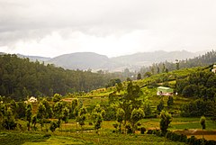
Nilgiri (góry)
 | |
| Kontynent | |
|---|---|
| Państwo | |
| Jednostka dominująca | |
| 11°22′30″N 76°45′40″E/11,375000 76,761111 | |
Nilgiri (tamil: நீலகிரி, malajalam: നീലഗിരി, kannada: ನೀಲಗಿರಿ, dosłownie: „Niebieskie Góry”) – pasmo górskie na styku stanów Karnataka, Kerala i Tamilnadu w południowych Indiach. Kilkanaście szczytów przekracza 2000 m wysokości. Pasmo Nilgiri stanowi część większego masywu Ghatów Zachodnich, rozciągającego się wzdłuż zachodniego wybrzeża Półwyspu Indyjskiego. Część gór znajduje się pod opieką UNESCO w ramach Rezerwatu Biosfery Nilgiri[1].
Przypisy
- ↑ Western Ghats (sub cluster nomination). [w:] Tentative Lists [on-line]. UNESCO. [dostęp 2022-11-04]. [zarchiwizowane z tego adresu (2012-05-25)]. (ang.).
Media użyte na tej stronie
Autor: Uwe Dedering, Licencja: CC BY-SA 3.0
Location map of India.
Equirectangular projection. Stretched by 106.0%. Geographic limits of the map:
- N: 37.5° N
- S: 5.0° N
- W: 67.0° E
- E: 99.0° E
The Flag of India. The colours are saffron, white and green. The navy blue wheel in the center of the flag has a diameter approximately the width of the white band and is called Ashoka's Dharma Chakra, with 24 spokes (after Ashoka, the Great). Each spoke depicts one hour of the day, portraying the prevalence of righteousness all 24 hours of it.
Black up-pointing triangle ▲, U+25B2 from Unicode-Block Geometric Shapes (25A0–25FF)
Autor: https://www.flickr.com/photos/sankaracs/, Licencja: CC BY 2.0
Emerald Lake near Ooty


