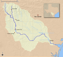
Nueces
| Ten artykuł od 2014-04 wymaga zweryfikowania podanych informacji. |
 | |
| Kontynent | |
|---|---|
| Państwo | |
| Rzeka | |
| Długość | 507 km |
| Źródło | |
| Współrzędne | |
| Ujście | |
| Recypient | |
| Miejsce | Zatoka Meksykańska |
| Współrzędne | |
Nueces – rzeka w południowo-zachodnich Stanach Zjednoczonych, w stanie Teksas, o długości 507 km[1].
Źródła rzeki znajdują się na Płaskowyżu Edwardsa w Hrabstwie Real, około 80 km na północ od miasta Uvalde. Rzeka płynie na południe poprzez region Texas Hill Country. Na wysokości Carrizo Springs skręca na wschód i przepływa obszar równin południowego Teksasu. W Mathis wypełnia zbiornik Corpus Christi. Następnie w mieście Corpus Christi wpływa do Zatoki Corpus Christi, która z kolei jest częścią Zatoki Meksykańskiej[2][3].
Do 1848 roku rzeka stanowiła granicę Teksasu i Meksyku[4][5].
Przypisy
- ↑ Nueces River, U.S. Geological Survey Geographic Names Information System, 1976–1981 [dostęp 2022-06-21] (ang.).
- ↑ Nueces River Project: Environmental Impact Statement, [w:] Google Books [online], Northwestern University, 1975, s. 26-27 [dostęp 2022-06-21] (ang.).
- ↑ Nueces Estuary (Corpus Christi Bay), Texas Water Development Board [dostęp 2022-06-21] (ang.).
- ↑ Robert S. Weddle, Nueces River, „Handbook of Texas Online”, Texas State Historical Association [dostęp 2022-06-21].
- ↑ David Pletcher Revised by Jesús "Frank" de la Teja, Treaty of Guadalupe Hidalgo, „Handbook of Texas Online”, Texas State Historical Association [dostęp 2022-06-21].
Linki zewnętrzne
- Nueces River Authority (ang.)
- Nueces River Handbook of Texas (ang.)
Media użyte na tej stronie
Autor: Uwe Dedering, Licencja: CC BY-SA 3.0
Relief location map of the USA (without Hawaii and Alaska).
EquiDistantConicProjection : Central parallel :
* N: 37.0° N
Central meridian :
* E: 96.0° W
Standard parallels:
* 1: 32.0° N
* 2: 42.0° N
Made with Natural Earth. Free vector and raster map data @ naturalearthdata.com.
Formulas for x and y:
x = 50.0 + 124.03149777329222 * ((1.9694462586094064-({{{2}}}* pi / 180))
      * sin(0.6010514667026994 * ({{{3}}} + 96) * pi / 180))
y = 50.0 + 1.6155950752393982 * 124.03149777329222 * 0.02613325650382181
      - 1.6155950752393982  * 124.03149777329222 *
     (1.3236744353715044  - (1.9694462586094064-({{{2}}}* pi / 180))
      * cos(0.6010514667026994 * ({{{3}}} + 96) * pi / 180))
The flag of Navassa Island is simply the United States flag. It does not have a "local" flag or "unofficial" flag; it is an uninhabited island. The version with a profile view was based on Flags of the World and as a fictional design has no status warranting a place on any Wiki. It was made up by a random person with no connection to the island, it has never flown on the island, and it has never received any sort of recognition or validation by any authority. The person quoted on that page has no authority to bestow a flag, "unofficial" or otherwise, on the island.
Autor: Autor nie został podany w rozpoznawalny automatycznie sposób. Założono, że to Kuru (w oparciu o szablon praw autorskich)., Licencja: CC BY-SA 2.5
This is a map of the Nueces River watershed. I, Kuru, created from data originating at the USGS.


