Oriel College w Oksfordzie
| ||
| University of Oxford | ||
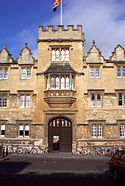
 Główne wejście do Oriel College | ||
| Data założenia | 1324 | |
| Patron | Dziewica Maryja | |
| Państwo | ||
| Kraj | ||
| Adres | Oksford | |
| Liczba studentów | 462 | |
| Dziekan | Derek Morris | |
Położenie na mapie Oksfordu Contains Ordnance Survey data © Crown copyright and database right, CC BY-SA 3.0 | ||
Położenie na mapie Wielkiej Brytanii (c) Karte: NordNordWest, Lizenz: Creative Commons by-sa-3.0 de | ||
Położenie na mapie Oxfordshire Contains Ordnance Survey data © Crown copyright and database right, CC BY-SA 3.0 | ||
| Strona internetowa | ||
Oriel College w Oksfordzie, Kolegium Oriel w Oksfordzie (pełna nazwa: ang. The House of the Blessed Mary the Virgin in Oxford, commonly called Oriel College, of the Foundation of Edward the Second of famous memory, sometime King of England, pol. „Dom Najświętszej Marii Panny w Oksfordzie, potocznie Kolegium Oriel zwany, fundacji szlachetnego Edwarda II, króla Anglii”)[1] jest jednym z kolegiów Uniwersytetu Oksfordzkiego.
Oriel College, założony 24 kwietnia 1324 roku przez Adama de Brome, został w lutym 1326 zatwierdzony przez króla Edwarda II, stając się tym samym pierwszym królewskim kolegium oksfordzkim[2].
Sławni absolwenci Oriel College w Oksfordzie
- Thomas Arundel – arcybiskup Canterbury,
- Walter Raleigh – odkrywca,
- Alexander Todd – laureat Nagrody Nobla z chemii,
- James Meade – laureat Nagrody im. Alfreda Nobla z ekonomii,
- John Keble – teolog
- Cecil John Rhodes – polityk
Przypisy
- ↑ Oxford University Calendar 2005-2006 (2005) — Oxford University Press ISBN 0-19-928370-2
- ↑ Watt, D. E. (editor), Oriel College, Oxford (1953) — Oxford University Archaeological Society
| ||||
Media użyte na tej stronie
(c) Karte: NordNordWest, Lizenz: Creative Commons by-sa-3.0 de
Location map of the United Kingdom
Flag of England. Saint George's cross (a red cross on a white background), used as the Flag of England, the Italian city of Genoa and various other places.
Autor: Autor nie został podany w rozpoznawalny automatycznie sposób. Założono, że to Wiki alf~commonswiki (w oparciu o szablon praw autorskich)., Licencja: CC-BY-SA-3.0
Photograph of the main gate of Oriel College, Oxford. Brightness slightly enhanced using Photoshop. Photo taken by me. --Alf melmac 17:53, 26 May 2006 (UTC)
Coat of Arms of Oxford University
Contains Ordnance Survey data © Crown copyright and database right, CC BY-SA 3.0
Map of Oxford, Oxfordshire, UK with electoral wards shown.
Equirectangular map projection on WGS 84 datum, with N/S stretched 160%
Geographic limits:
- West: 1.32W
- East: 1.17W
- North: 51.81N
- South: 51.69N
Contains Ordnance Survey data © Crown copyright and database right, CC BY-SA 3.0
Map of Oxfordshire, UK with the following information shown:
- Administrative borders
- Coastline, lakes and rivers
- Roads and railways
- Urban areas
Equirectangular map projection on WGS 84 datum, with N/S stretched 160%
Geographic limits:
- West: 1.74W
- East: 0.72W
- North: 52.19N
- South: 51.44N


