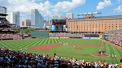
Oriole Park at Camden Yards
 | |
| Państwo | |
|---|---|
| Miejscowość | |
| Koszt budowy | 110 milionów dolarów |
| Data budowy | 1989–1992 |
| Klub | |
| Pojemność stadionu | 45 971 |
| Strona internetowa | |
Oriole Park at Camden Yards – stadion baseballowy w Baltimore w stanie Maryland, na którym swoje mecze rozgrywa zespół Baltimore Orioles.
Budowę obiektu rozpoczęto w czerwcu 1989, zaś zakończono w 1992 roku[1]. Pierwszy mecz miał miejsce 6 kwietnia 1992; Orioles podejmowali Cleveland Indians[2]. W 1993 był areną Meczu Gwiazd[1]. 6 września 1995 na Oriole Park w meczu z Los Angeles Angels of Anaheim Cal Ripken Jr. pobił rekord należący do Lou Gehriga, występując w 2131 kolejnych spotkaniach[3]. 8 października 1995 na stadionie mszę odprawił papież Jan Paweł II[4].
Przypisy
- ↑ a b Oriole Park at Camden Yards, Baltimore, Maryland. ballparksofbaseball.com. [dostęp 2013-07-27]. (ang.).
- ↑ Oriole Park at Camden Yards, Baltimore, MD. ballparksofbaseball.com. [dostęp 2015-12-23]. (ang.).
- ↑ Iron Man Ripken. mlb.com. [dostęp 2015-12-23]. (ang.).
- ↑ Homily Of His Holiness John Paul II. vatican.va. [dostęp 2015-12-23]. (ang.).
Media użyte na tej stronie
Autor: Uwe Dedering, Licencja: CC BY-SA 3.0
Location map of the USA (without Hawaii and Alaska).
EquiDistantConicProjection:
Central parallel:
* N: 37.0° N
Central meridian:
* E: 96.0° W
Standard parallels:
* 1: 32.0° N
* 2: 42.0° N
Made with Natural Earth. Free vector and raster map data @ naturalearthdata.com.
Formulas for x and y:
x = 50.0 + 124.03149777329222 * ((1.9694462586094064-({{{2}}}* pi / 180))
      * sin(0.6010514667026994 * ({{{3}}} + 96) * pi / 180))
y = 50.0 + 1.6155950752393982 * 124.03149777329222 * 0.02613325650382181
      - 1.6155950752393982  * 124.03149777329222 *
     (1.3236744353715044  - (1.9694462586094064-({{{2}}}* pi / 180))
      * cos(0.6010514667026994 * ({{{3}}} + 96) * pi / 180))
The flag of Navassa Island is simply the United States flag. It does not have a "local" flag or "unofficial" flag; it is an uninhabited island. The version with a profile view was based on Flags of the World and as a fictional design has no status warranting a place on any Wiki. It was made up by a random person with no connection to the island, it has never flown on the island, and it has never received any sort of recognition or validation by any authority. The person quoted on that page has no authority to bestow a flag, "unofficial" or otherwise, on the island.
Autor:
- Gfi-set01-stadium.png: gfi
- derivative work: Frédéric (talk)
icone pour terrain de sport
Autor: OpenStreetMap contributors, Licencja: CC BY-SA 2.0
Map of Baltimore
Geographic limits of the map:
- N: 39.3805°
- S: 39.1953°
- W: -76.7426°
- E: -76.4957°
Autor: Keith Allison, Licencja: CC BY-SA 2.0
Oriole Park at Camden Yard during that national anthem prior to an afternoon game.


