Perivale
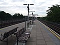
 Budynek stacji Perivale, 2008 | |
| Państwo | |
|---|---|
| Miejscowość | Londyn |
| Dzielnica | Perivale |
| Data otwarcia | 1947 |
| Liczba peronów | 2 |
| Central Line | |
| Poprzednia stacja | Greenford |
| Następna stacja | Hanger Lane |
Położenie na mapie gminy Ealing  Contains Ordnance Survey data © Crown copyright and database right, CC BY-SA 3.0 | |
Położenie na mapie Wielkiej Brytanii  (c) Karte: NordNordWest, Lizenz: Creative Commons by-sa-3.0 de | |
Położenie na mapie Anglii  | |
Położenie na mapie Wielkiego Londynu  Contains Ordnance Survey data © Crown copyright and database right, CC BY-SA 3.0 | |
| Portal | |
Perivale – stacja londyńskiego metra położona w północno-zachodniej części miasta, na trasie Central Line pomiędzy stacjami Greenford a Hanger Lane. Znajduje się w dzielnicy Perivale w gminie London Borough of Ealing, w czwartej strefie biletowej[1].
Linie kolejowe Great Western Railway otworzyły stację "Perivale Halt" 2 maja 1904 roku. Obecna stacja London Underground została otwarta 30 czerwca 1947 roku[2]. Budynek stacji jest jednym z 16 stacji metra w Londynie umieszczonych 26 lipca 2011 roku na liście zabytków[3].
Stację obsługuje linia autobusowa 297.
Galeria

Peron w kierunku zachodnim
Peron w kierunku wschodnim

Symbol stacji
Przypisy
- ↑ Tube stations - Perivale (ang.). Transport For London. [dostęp 2012-01-05].
- ↑ Central line facts (ang.). Transport For London. [dostęp 2012-01-05].
- ↑ Sixteen London tube stations become listed buildings (ang.). Department for Culture, Media and Sport. [dostęp 2012-01-05].
| Linia główna | |
|---|---|
| Odgałęzienie West Ruislip | |
| Odgałęzienie Ealing Broadway | |
| Odgałęzienie Woodford | |
| Odgałęzienie Epping |
![]()
Media użyte na tej stronie
(c) Karte: NordNordWest, Lizenz: Creative Commons by-sa-3.0 de
Location map of the United Kingdom


Autor: Sunil060902, Licencja: CC BY-SA 3.0
Perivale tube station looking west with some remedial work in progress to the canopies and the station entrance (extreme left). Ex-GWR twin tracks for freight/occasional use visible on extreme right.

Autor: Sunil060902, Licencja: CC BY-SA 3.0
Perivale tube station looking east, with twin ex-GWR tracks for freight/occasional use on the extreme left
Contains Ordnance Survey data © Crown copyright and database right, CC BY-SA 3.0
Blank map of the London Borough of Ealing, showing electoral wards used from 2002 to 2022.
Equirectangular map projection on WGS 84 datum, with N/S stretched 160%
Geographic limits:
- West: 0.425W
- East: 0.24W
- North: 51.565N
- South: 51.485N
Autor: Sunil060902, Licencja: CC BY-SA 3.0
Perivale tube station, July 2008, just after recent refurbishment work to the upper facade.
Contains Ordnance Survey data © Crown copyright and database right, CC BY-SA 3.0
Map of Greater London, UK with the following information shown:
- Administrative borders
- Coastline, lakes and rivers
- Roads and railways
- Urban areas
The data includes both primary routes and railway lines.
Equirectangular map projection on WGS 84 datum, with N/S stretched 160%
Geographic limits:
- West: 0.57W
- East: 0.37E
- North: 51.72N
- South: 51.25N

Autor: Sunil060902, Licencja: CC BY-SA 3.0
Roundel on Perivale tube station platform westbound face