Peru (Nowy Jork)
| ||||
 | ||||
| Państwo | ||||
|---|---|---|---|---|
| Stan | ||||
| Hrabstwo | ||||
| Kod statystyczny | ||||
| Powierzchnia | 239,3 km² | |||
| Wysokość | 133 m n.p.m. | |||
| Populacja (2010) • liczba ludności • gęstość |
| |||
| Nr kierunkowy | 518 | |||
| Kod pocztowy | 12972 | |||
| Strefa czasowa | ||||
Położenie na mapie stanu Nowy Jork (c) NordNordWest, CC BY 3.0 | ||||
| Strona internetowa | ||||
| Portal | ||||
Peru – miasto w Stanach Zjednoczonych, w stanie Nowy Jork, w hrabstwie Clinton.
Przypisy
- ↑ American FactFinder - Community Facts. [dostęp 2015-02-14]. [zarchiwizowane z tego adresu (2015-01-18)].
Media użyte na tej stronie
(c) NordNordWest, CC BY 3.0
Location map of the State of New York, USA
Autor: Uwe Dedering, Licencja: CC BY-SA 3.0
Location map of the USA (without Hawaii and Alaska).
EquiDistantConicProjection:
Central parallel:
* N: 37.0° N
Central meridian:
* E: 96.0° W
Standard parallels:
* 1: 32.0° N
* 2: 42.0° N
Made with Natural Earth. Free vector and raster map data @ naturalearthdata.com.
Formulas for x and y:
x = 50.0 + 124.03149777329222 * ((1.9694462586094064-({{{2}}}* pi / 180))
      * sin(0.6010514667026994 * ({{{3}}} + 96) * pi / 180))
y = 50.0 + 1.6155950752393982 * 124.03149777329222 * 0.02613325650382181
      - 1.6155950752393982  * 124.03149777329222 *
     (1.3236744353715044  - (1.9694462586094064-({{{2}}}* pi / 180))
      * cos(0.6010514667026994 * ({{{3}}} + 96) * pi / 180))
The flag of Navassa Island is simply the United States flag. It does not have a "local" flag or "unofficial" flag; it is an uninhabited island. The version with a profile view was based on Flags of the World and as a fictional design has no status warranting a place on any Wiki. It was made up by a random person with no connection to the island, it has never flown on the island, and it has never received any sort of recognition or validation by any authority. The person quoted on that page has no authority to bestow a flag, "unofficial" or otherwise, on the island.
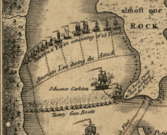
en:Battle of Valcour Island, en:1776, showing position of American ships on en:Lake Champlain
between the en:New York State coastline and en:Valcour Island on the right. From: en:Library of Congress, Geography and Map Division.
According to the LOC source website[1]:
Copyright and Restrictions Most maps in the Map Collections materials were either published prior to 1922, produced by the United States government, or both (see catalogue records that accompany each map for information regarding date of publication and source). A few have permission from the copyright holders as noted in the descriptive record. The Library of Congress is providing access to these materials for educational and research purposes and is not aware of any U.S. copyright protection (see Title 17 of the United States Code) or any other restrictions in the Map Collection materials.
Note that the written permission of the copyright owners and/or other rights holders (such as publicity and/or privacy rights) is required for distribution, reproduction, or other use of protected items beyond that allowed by fair use or other statutory exemptions. Responsibility for making an independent legal assessment of an item and securing any necessary permissions ultimately rests with persons desiring to use the item.
See our Legal Notices for additional information and restrictions.


