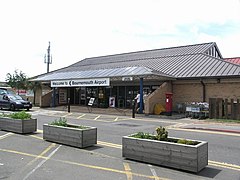
Port lotniczy Bournemouth
(c) Mike Smith, CC BY-SA 2.0 | |||
| Państwo | |||
|---|---|---|---|
| Kraj | |||
| Miejscowość | |||
| Typ | cywilne | ||
| Właściciel | Manchester Airports Group | ||
| Kod IATA | BOH | ||
| Kod ICAO | EGHH | ||
| Wysokość | 12 m n.p.m. | ||
| Statystyki ruchu (2015[1]) | |||
| Liczba pasażerów | 705 433 | ||
| Liczba operacji | 43 020 | ||
| Drogi startowe | |||
| |||
Położenie na mapie Dorsetu Contains Ordnance Survey data © Crown copyright and database right, CC BY-SA 3.0 | |||
Położenie na mapie Wielkiej Brytanii (c) Karte: NordNordWest, Lizenz: Creative Commons by-sa-3.0 de | |||
Port lotniczy Bornemouth (kod IATA: BOH, kod ICAO: EGHH) (ang.: Bornemouth Airport) – międzynarodowe lotnisko położone ok. 8 km od Bournemouth w hrabstwie Dorset w Anglii. Jest to 22. port lotniczy Wielkiej Brytanii pod względem ruchu pasażerskiego.
Linie lotnicze i połączenia regularne
| Linia lotnicza | Kierunek |
|---|---|
| EasyJet | Sezonowo: |
| Ryanair | Sezonowo: |
Czartery
| Linia lotnicza | Kierunek |
|---|---|
| First Choice Airways | Sezonowo:
|
| Palmair | |
| Thomsonfly | Sezonowo:
|
Przypisy
- ↑ Data and analysis | UK Civil Aviation Authority, www.caa.co.uk [dostęp 2017-11-26] (ang.).
- ↑ Tanie loty z Bournemouth do Genewa (pol.). easyJet. [dostęp 2016-05-19].
- ↑ Anna Żuchlińska: Ryanair: Z Krakowa polecimy do Bournemouth (pol.). pasazer.com, 2016-05-12. [dostęp 2016-05-19].
Linki zewnętrzne
Media użyte na tej stronie
(c) Karte: NordNordWest, Lizenz: Creative Commons by-sa-3.0 de
Location map of the United Kingdom
Flag of England. Saint George's cross (a red cross on a white background), used as the Flag of England, the Italian city of Genoa and various other places.
Icon representing an increase, consisting of a green-colored, up-pointing triangle.
Icon representing a decrease, consisting of a red-colored, down-pointing triangle.
Symbol lotniska do legendy mapy
Autor: Pedro A. Gracia Fajardo, escudo de Manual de Imagen Institucional de la Administración General del Estado, Licencja: CC0
Flaga Hiszpanii
Flag of Portugal, created by Columbano Bordalo Pinheiro (1857-1929), officially adopted by Portuguese government in June 30th 1911 (in use since about November 1910). Color shades matching the RGB values officially reccomended here. (PMS values should be used for direct ink or textile; CMYK for 4-color offset printing on paper; this is an image for screen display, RGB should be used.)
The flag of the Dominican Republic has a centered white cross that extends to the edges. This emblem is similar to the flag design and shows a bible, a cross of gold and 6 Dominican flags. There are branches of olive and palm around the shield and above on the ribbon is the motto "Dios,Patria!, Libertad" ("God, Country, Freedom") and to amiable freedom. The blue is said to stand for liberty, red for the fire and blood of the independence struggle and the white cross symbolized that God has not forgotten his people. "Republica Dominicana". The Dominican flag was designed by Juan Pablo Duarte, father of the national Independence of Dominican Republic. The first dominican flag was sewn by a young lady named Concepción Bona, who lived across the street of El Baluarte, monument where the patriots gathered to fight for the independence, the night of February 27th, 1844. Concepción Bona was helped by her first cousin María de Jesús Pina.
(c) Mike Smith, CC BY-SA 2.0
Entrance to Bournemouth Airport building.
Contains Ordnance Survey data © Crown copyright and database right, CC BY-SA 3.0
Map of Dorset, UK with the following information shown:
- Administrative borders
- Coastline, lakes and rivers
- Roads and railways
- Urban areas
Equirectangular map projection on WGS 84 datum, with N/S stretched 155%
Geographic limits:
- West: 2.99W
- East: 1.65W
- North: 51.10N
- South: 50.50N


