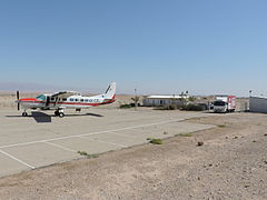
Port lotniczy En Jahaw
 | |||
| Państwo | |||
|---|---|---|---|
| Miejscowość | |||
| Właściciel | Israel Airports Authority | ||
| Kod IATA | EIY | ||
| Kod ICAO | LLEY | ||
| Wysokość | -50 m n.p.m. | ||
| Drogi startowe | |||
| |||
Port lotniczy En Jahaw (hebr. מנחת ספיר) (IATA: EIY, ICAO: LLEY) – lotnisko położone we wschodniej części pustyni Negew, w Izraelu, przy samej granicy z Jordanią, pomiędzy Morzem Martwym a Ejlatem, w pobliżu wioski Sappir oraz moszawu En Jahaw.
Historia
Lotnisko zostało wybudowane w 1970.
Linie lotnicze i połączenia
- Elrom Airways (Tel Awiw-Sede Dow)
Linki zewnętrzne
- Port lotniczy En Jahaw. [dostęp 2009-11-15].
Media użyte na tej stronie
Autor: NordNordWest, Licencja: CC BY-SA 3.0
Flag of Israel. Shows a Magen David (“Shield of David”) between two stripes. The Shield of David is a traditional Jewish symbol. The stripes symbolize a Jewish prayer shawl (tallit).
Symbol lotniska do legendy mapy
Autor: Oyoyoy, Licencja: CC BY-SA 4.0
4X-CZL at Ein Yahav landing strip


