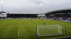
Proact Stadium
 | |
| Państwo | |
|---|---|
| Kraj | |
| Miejscowość | |
| Data budowy | 2009-2010 |
| Data otwarcia | 2010 |
| Klub | |
| Pojemność stadionu | 10 504 |
| Rekordowa frekwencja | 10 089[1] |
Położenie na mapie Derbyshire Contains Ordnance Survey data © Crown copyright and database right, CC BY-SA 3.0 | |
Położenie na mapie Wielkiej Brytanii (c) Karte: NordNordWest, Lizenz: Creative Commons by-sa-3.0 de | |
| Strona internetowa | |
Proact Stadium – stadion piłkarski w Chesterfield w hrabstwie Derbyshire, którego budowę rozpoczęto w lipcu 2009 roku. Oficjalne otwarcie nastąpiło przed rozpoczęciem sezonu 2010/11; całkowity koszt jego budowy wyniósł 13 mln funtów[2]. Pojemność obiektu to 10 504 miejsc[2].
Pierwsze spotkanie ligowe drużyna Chesterfield rozegrała 7 sierpnia 2010 roku; przeciwnikiem był zespół Barnet[3].
8 lutego 2011 roku na B2net Stadium odbył się mecz reprezentacji do lat 19 pomiędzy Anglią a Niemcami; zwyciężyli goście 1:0[4].
Przypisy
- ↑ Chesterfield 5-0 Rotherham. BBC Sport. [dostęp 2011-11-26]. (ang.).
- ↑ a b About Proact Stadium. footballgroundmap.com. [dostęp 2017-09-24]. (ang.).
- ↑ Chesterfield vs Barnet. Chesterfield FC. [dostęp 2011-11-26]. (ang.).
- ↑ England’s Under 19s Beaten by a Single German Goal. The Youth Radar. [dostęp 2011-11-26]. (ang.).
Media użyte na tej stronie
(c) Karte: NordNordWest, Lizenz: Creative Commons by-sa-3.0 de
Location map of the United Kingdom
Flag of England. Saint George's cross (a red cross on a white background), used as the Flag of England, the Italian city of Genoa and various other places.
Autor:
- Gfi-set01-stadium.png: gfi
- derivative work: Frédéric (talk)
icone pour terrain de sport
Contains Ordnance Survey data © Crown copyright and database right, CC BY-SA 3.0
Map of Derbyshire, UK with the following information shown:
- Administrative borders
- Coastline, lakes and rivers
- Roads and railways
- Urban areas
Equirectangular map projection on WGS 84 datum, with N/S stretched 165%
Geographic limits:
- West: 2.06W
- East: 1.10W
- North: 53.55N
- South: 52.69N


