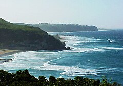
Quebradillas (Portoryko)
 | |||||
| Państwo | |||||
|---|---|---|---|---|---|
| Terytorium nieinkorporowane | |||||
| Hrabstwo | Quebradillas | ||||
| Powierzchnia | 4,19 km² | ||||
| Wysokość | 102 m n.p.m. | ||||
| Populacja • liczba ludności |
| ||||
| Kod pocztowy | 00678 | ||||
| Strona internetowa | |||||
| Portal | |||||
Quebradillas – miasto w Portoryko, w gminie Quebradillas.
Kontrola autorytatywna (municipality of Puerto Rico):
Media użyte na tej stronie
USA Puerto Rico location map.svg
Autor: NordNordWest, Licencja: CC BY-SA 3.0
Location map of Puerto Rico, USA
Autor: NordNordWest, Licencja: CC BY-SA 3.0
Location map of Puerto Rico, USA
Flag of the United States.svg
The flag of Navassa Island is simply the United States flag. It does not have a "local" flag or "unofficial" flag; it is an uninhabited island. The version with a profile view was based on Flags of the World and as a fictional design has no status warranting a place on any Wiki. It was made up by a random person with no connection to the island, it has never flown on the island, and it has never received any sort of recognition or validation by any authority. The person quoted on that page has no authority to bestow a flag, "unofficial" or otherwise, on the island.
The flag of Navassa Island is simply the United States flag. It does not have a "local" flag or "unofficial" flag; it is an uninhabited island. The version with a profile view was based on Flags of the World and as a fictional design has no status warranting a place on any Wiki. It was made up by a random person with no connection to the island, it has never flown on the island, and it has never received any sort of recognition or validation by any authority. The person quoted on that page has no authority to bestow a flag, "unofficial" or otherwise, on the island.
Flag of Quebradillas.svg
Autor: CarlosArturoAcosta, Licencja: CC BY-SA 4.0
Bandera del municipio puertorriqueño de Quebradillas: La bandera de Quebradillas está dividida en cuatro partes: el cuadrado superior izquierdo y el cuadrado inferior derecho son rojos, que significan lucha, esfuerzo y sacrificio. El lado superior derecho y el lado inferior izquierdo contienen cinco franjas onduladas. Las franjas blancas significan paz y serenidad. Las franjas verdes simbolizan las innumerables quebradas o quebraditas que atraviesan este territorio y que forman parte de nuestra topografía.
Guajatacatunel.jpg
Autor: Mistman123, Licencja: CC BY-SA 4.0
View of the train tunnel and coast at Quebradillas, Puerto Rico
Autor: Mistman123, Licencja: CC BY-SA 4.0
View of the train tunnel and coast at Quebradillas, Puerto Rico


