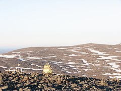
Ridnitsohkka
 | |
| Państwo | |
|---|---|
| Położenie | |
| Pasmo | |
| Wysokość | 1317 m n.p.m. |
Ridnitsohkka – szczyt w Górach Skandynawskich. Leży w Finlandii, w Laponii. Jest to najwyższy szczyt leżący na terenie Finlandii, choć nie najwyższy punkt tego kraju[1][2] (jest nim punkt na stoku Haltiatunturi, 1323,6 m n.p.m., wierzchołek osiąga wysokość – 1365 m n.p.m. – leży jednak po stronie norweskiej).
Ridnitsohkka znajduje się 50 km od najbliższej wioski (Kilpisjärvi). Na szczycie znajduje się niewielki maszt telekomunikacyjny.
Przypisy
- ↑ Halti (ang.). [dostęp 2009-11-21].
- ↑ Suomen sormenpäillä (fiń.). [dostęp 2009-11-21].
Media użyte na tej stronie
Flaga Finlandii
Black up-pointing triangle ▲, U+25B2 from Unicode-Block Geometric Shapes (25A0–25FF)
Autor: Matti Paavola (User:MattiPaavola), Licencja: CC BY-SA 3.0
Ridnitšohkka fell in background and boundary mark 303B on foreground. 303B is the highest point in Finland and is located on Halti fell. On the other hand, Ridnitšohkka is the highest fell in Finland with its peak entirely in the Finnish side of the border. The photo is taken in the evening the 8th of July, 2008 from Norwegian side of Halti. The "mailbox" on left contains the visitors' book of Halti.


