Roker Park
(c) John Harvey, CC BY-SA 2.0 | |
| Roker Park | |
| Państwo | |
|---|---|
| Kraj | |
| Data otwarcia | 1898 |
| Data zamknięcia | 1997 |
| Klub | Sunderland A.F.C. (1898–1997) |
| Pojemność stadionu | 22 500 |
| Rekordowa frekwencja | 75 118 |
| Wymiary boiska | 112 x 78 m |
| Nawierzchnia boiska | trawa |
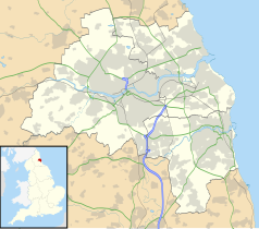
Położenie na mapie Tyne and Wear Contains Ordnance Survey data © Crown copyright and database right, CC BY-SA 3.0 | |
Położenie na mapie Wielkiej Brytanii (c) Karte: NordNordWest, Lizenz: Creative Commons by-sa-3.0 de | |
Roker Park – dawny stadion znajdujący się w mieście Sunderland w Anglii. Na tym obiekcie rozegrano cztery spotkania Mistrzostw Świata w Piłce Nożnej 1966. Swoje mecze rozgrywał na nim zespół Sunderland A.F.C. W ostatnich latach funkcjonowania pojemność obiektu wynosiła 22 500. Został zburzony w 1997 roku.
Bibliografia
- Roker Park (ang.). stadiumguide.com. [dostęp 2021-05-02].
Media użyte na tej stronie
Contains Ordnance Survey data © Crown copyright and database right, CC BY-SA 3.0
Map of Tyne and Wear, UK, with the following information shown:
- Administrative borders
- Coastline, lakes and rivers
- Roads and railways
- Urban areas
Equirectangular map projection on WGS 84 datum, with N/S stretched 170%
Geographic limits:
- West: 1.90W
- East: 1.30W
- North: 55.09N
- South: 54.78N
(c) Karte: NordNordWest, Lizenz: Creative Commons by-sa-3.0 de
Location map of the United Kingdom
Flag of England. Saint George's cross (a red cross on a white background), used as the Flag of England, the Italian city of Genoa and various other places.
Autor:
- Gfi-set01-stadium.png: gfi
- derivative work: Frédéric (talk)
icone pour terrain de sport
(c) John Harvey, CC BY-SA 2.0
Roker Park August 1976 This is Sunderland about to kick off over 30 years ago against Arsenal. The Roker End to the left is uncovered and the stand opposite was known as the Clock Stand. If you look carefully you can see the Match of The Day cameras on top of the stand. The ground is now gone and has a housing estate built on it now. I think there maybe a Clock Stand Drive. There is also a Goalmouth Close and of course the aptly named Promotion Close. Happy Days.


