Sèvres – Babylone
| ||
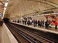
 Perony stacji na linii nr 10 | ||
| Państwo | ||
| Miejscowość | Paryż | |
| Data otwarcia | 30 grudnia 1923 - linia nr 10 5 listopada 1910 - linia nr 12 | |
| Poprzednia stacja | Vaneau | |
| Następna stacja | Mabillon | |
| Poprzednia stacja | Rue du Bac | |
| Następna stacja | Rennes | |
Położenie na mapie Paryża  (c) Eric Gaba, Wikimedia Commons user Sting, CC BY-SA 3.0 | ||
Położenie na mapie Francji  | ||
Położenie na mapie Île-de-France .svg "Mapa lokalizacyjna Île-de-France") | ||
| Portal | ||
Sèvres - Babylone – stacja 10 i 12 linii metra w Paryżu. Stacja znajduje się na granicy 6. i 7. dzielnicy Paryża. Na linii nr 10 stacja została otwarta 30 grudnia 1923 r, a na linii nr 12 - 5 listopada 1910.

Perony stacji na linii nr 12
Perony stacji na linii nr 12
Zobacz też
| ||||||||||
Media użyte na tej stronie
Paris department land cover location map.svg
(c) Eric Gaba, Wikimedia Commons user Sting, CC BY-SA 3.0
Blank land cover map of the city and department of Paris, France, as in January 2012, for geo-location purpose, with distinct boundaries for departments and arrondissements.
(c) Eric Gaba, Wikimedia Commons user Sting, CC BY-SA 3.0
Blank land cover map of the city and department of Paris, France, as in January 2012, for geo-location purpose, with distinct boundaries for departments and arrondissements.
France location map-Regions and departements-2016.svg
Autor: Superbenjamin, Licencja: CC BY-SA 4.0
Blank administrative map of France for geo-location purpose, with regions and departements distinguished. Approximate scale : 1:3,000,000
Autor: Superbenjamin, Licencja: CC BY-SA 4.0
Blank administrative map of France for geo-location purpose, with regions and departements distinguished. Approximate scale : 1:3,000,000


Logo Paris tram ligne2.svg
Logo de la ligne de tram 2 de Paris
Logo de la ligne de tram 2 de Paris
Carte de l'Île de France (administrative).svg
Autor: Thibault Pelloquin, Licencja: CC BY-SA 3.0
Cette carte représente l'Île de France (en jaune pâle), ses limites départementales et régionales (en traits gris) et ses principaux cours et points d'eau (en bleu). Les départements limitrophes (sont en rose-orange pâle)
Autor: Thibault Pelloquin, Licencja: CC BY-SA 3.0
Cette carte représente l'Île de France (en jaune pâle), ses limites départementales et régionales (en traits gris) et ses principaux cours et points d'eau (en bleu). Les départements limitrophes (sont en rose-orange pâle)
Metro de Paris - Ligne 10 - Sevres - Babylone 02.jpg
Autor: Clicsouris, Licencja: CC BY-SA 3.0
Station Sèvres - Babylone de la ligne 10 du métro de Paris, France.
Autor: Clicsouris, Licencja: CC BY-SA 3.0
Station Sèvres - Babylone de la ligne 10 du métro de Paris, France.
Paris m 10 jms.svg
Transit icon for Line 10 of the Paris Métro. See {{Paris transit icons}} for colour standards.
Transit icon for Line 10 of the Paris Métro. See {{Paris transit icons}} for colour standards.
- own work
- line-art inspired by contemporary metro plans


Metro Sevres Babylone.jpg
Autor: Autor nie został podany w rozpoznawalny automatycznie sposób. Założono, że to Luidger (w oparciu o szablon praw autorskich)., Licencja: CC-BY-SA-3.0
Autor: Autor nie został podany w rozpoznawalny automatycznie sposób. Założono, że to Luidger (w oparciu o szablon praw autorskich)., Licencja: CC-BY-SA-3.0
Metro, Sevres-Babylone, Paris, Frankreich, France
Photograph Luidger (27. August 2005)
Paris m 12 jms.svg
Transit icon for Line 12 of the Paris Métro. See {{Paris transit icons}} for colour standards.
Transit icon for Line 12 of the Paris Métro. See {{Paris transit icons}} for colour standards.
- own work
- line-art inspired by contemporary metro plans

Metro de Paris - Ligne 12 - Sevres - Babylone 01.jpg
Autor: Clicsouris, Licencja: CC BY-SA 3.0
Station Sèvres - Babylone de la ligne 12 du métro de Paris, France.
Autor: Clicsouris, Licencja: CC BY-SA 3.0
Station Sèvres - Babylone de la ligne 12 du métro de Paris, France.

Metro-M.svg
Logo Metro w Paryżu
Logo Metro w Paryżu