Schöntal
| gmina | |||
 | |||
| |||
| Państwo | |||
|---|---|---|---|
| Kraj związkowy | |||
| Rejencja | Stuttgart | ||
| Powiat | Hohenlohe | ||
| Związek regionalny | Heilbronn-Franken | ||
| Kod statystyczny | 08 1 26 072 | ||
| Powierzchnia | 81,65 km² | ||
| Wysokość | 200-334 m n.p.m. | ||
| Populacja (31 grudnia 2010) • liczba ludności | 5 696 | ||
| • gęstość | 70 os./km² | ||
| Numer kierunkowy | 06294, 07943 | ||
| Kod pocztowy | 74214 | ||
| Tablice rejestracyjne | KÜN, ÖHR | ||
Adres urzędu: Klosterhof 174214 Schöntal | |||
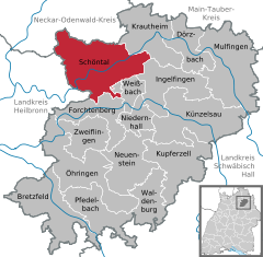
Położenie na mapie powiatu | |||
| 49°20′N 9°30′E/49,333333 9,500000 | |||
| Strona internetowa | |||
| Portal | |||
Schöntal – miejscowość i gmina w Niemczech, w kraju związkowym Badenia-Wirtembergia, w rejencji Stuttgart, w regionie Heilbronn-Franken, w powiecie Hohenlohe. Leży nad rzeką Jagst, ok. 12 km na północny zachód od Künzelsau, przy linii kolejowej Dörzbach–Möckmühl.
Zobacz też
- Schönthal
Media użyte na tej stronie
Autor: p.schmelzle, Licencja: CC BY-SA 2.5
Barockkirche Kloster Schöntal
Autor: Christian Spannagel, Licencja: CC BY-SA 2.0
Kloster Schöntal
|
|
|
|
|
|
|
|
Autor: Rosenzweig, Licencja: CC-BY-SA-3.0
The former Schöntal monastery as seen from the abbey garden in the North


