Sikkim
| stan | |||
 | |||
| |||
| Państwo | |||
|---|---|---|---|
| Siedziba | |||
| Kod ISO 3166-2 | IN-SK | ||
| Gubernator | Balmiki Prasad Singh | ||
| Premier | |||
| Powierzchnia | 7096 km² | ||
| Populacja (2011) • liczba ludności |
| ||
| • gęstość | 85,6 os./km² | ||
| Języki urzędowe | |||
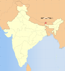
Położenie na mapie Indii | |||
| Strona internetowa | |||
Sikkim (hindi, nepal. सिक्किम, trb.: Sikkim, trl.: Sikkim; ang. Sikkim) – jeden ze stanów Indii, położony w ich północno-wschodniej części, po Goa najmniejszy pod względem powierzchni. Stolicą stanu jest miasto Gangtok.
W XIX wieku brytyjski protektorat, od 1947 roku formalnie niezależna monarchia (za sprawy zagraniczne odpowiedzialne były Indie) z własnym królem z dynastii Namgjalów, tytułujących się jako czogjalowie (tyb. czogjal – boski władca). Od 1975 r., po plebiscycie, w którym 97% obywateli wypowiedziało się za detronizacją króla i przyłączeniem do Indii, jest integralną częścią tego państwa.
Symbolem tego stanu jest kuropatnik.
Podział administracyjny
Stan Sikkim dzieli się na cztery okręgi:
- Sikkim Północny
- Sikkim Południowy
- Sikkim Wschodni
- Sikkim Zachodni
Władcy Sikkimu
- Phuntsog Namgyal – 1642–1670
- Tensung Namgyal – 1670–1700
- Chakdor Namgyal – 1700–1717
- Gyurmed Namgyal – 1717–1733
- Phuntsog Namgyal II – 1733–1780
- Tenzing Namgyal – 1780–1793
- Tsugphud Namgyal – 1793–1863
- Sidkeong Namgyal – 1863–1874
- Thutob Namgyal – 1874–1914
- Sidkeong Tulku Namgyal – 1914
- Tashi Namgyal – 1914–1963
- Palden Thondup Namgyal – 1963–1975
Pretendenci do tronu
- Palden Thondup Namgyal – 1975–1982
- Wangchuk Namgyal – od 1982
Przypisy
- ↑ 3. Size, Growth Rate and Distribution of Population, [w:] 2011 Census of India, Office of the Registrar General & Census Commissioner, India [dostęp 2019-08-02] [zarchiwizowane z adresu 2019-05-31].
Media użyte na tej stronie
Autor:
This Image was created by User:PlaneMad.
|
Autor: Nieznany (flag design), first version of SVG file uploaded by Nichalp, subsequent edits by User:Goran_tek-en and AnonMoos, Licencja: CC BY-SA 2.5
Flag of Sikkim, in use from 1967 to 1975
The Flag of India. The colours are saffron, white and green. The navy blue wheel in the center of the flag has a diameter approximately the width of the white band and is called Ashoka's Dharma Chakra, with 24 spokes (after Ashoka, the Great). Each spoke depicts one hour of the day, portraying the prevalence of righteousness all 24 hours of it.
Autor: Ashinpt at enwiki, Licencja: CC-BY-SA-3.0
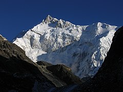
Picture of Kangchenjunga taken by author from Goecha La pass, 4940m, Sikkim. The peak in the image is actually the South peak of Kangchenjunga, which is about 400 ft lower than the main peak. You can also see the West peak of Kangchenjunga (Yalung Kang) as the round peak slightly to the left of the South Ridge (the ridge going left from the South peak).


