Son (rzeka)
| ||
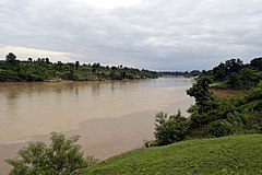
This file is not in the public domain. Therefore you are requested to use the following next to the image if you reuse this file: © Yann Forget / Wikimedia Commons, CC BY-SA 4.0 Widok na rzekę Son, dystrykt Umaria, Madhya Pradesh | ||
| Kontynent | Azja | |
| Państwo | ||
| Rzeka | ||
| Długość | 784 km | |
| Powierzchnia zlewni | 71 900 km² | |
| Źródło | ||
| Miejsce | Dekan | |
| Ujście | ||
| Recypient | Ganges | |
| Współrzędne | 25°42′09″N 84°51′54″E/25,702500 84,865000 | |
Son – rzeka w Indiach o długości 784 km oraz powierzchni dorzecza 71 900 km²
Źródła rzeki znajdują się na wyżynie Dekan, a uchodzi ona do rzeki Ganges.
Rzeka Son jest wykorzystywana do nawadniania pól uprawnych oraz w dolnym biegu do żeglugi.
Media użyte na tej stronie
The Flag of India. The colours are saffron, white and green. The navy blue wheel in the center of the flag has a diameter approximately the width of the white band and is called Ashoka's Dharma Chakra, with 24 spokes (after Ashoka, the Great). Each spoke depicts one hour of the day, portraying the prevalence of righteousness all 24 hours of it.
This file is not in the public domain. Therefore you are requested to use the following next to the image if you reuse this file: © Yann Forget / Wikimedia Commons, CC BY-SA 4.0
Son River, Umaria district, Madhya Pradesh, India.
Autor: Uwe Dedering, Licencja: CC BY-SA 3.0
Location map of India.
Equirectangular projection. Stretched by 106.0%. Geographic limits of the map:
- N: 37.5° N
- S: 5.0° N
- W: 67.0° E
- E: 99.0° E


