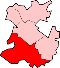
South Shropshire
| dystrykt niemetropolitalny | |
 Ludlow | |
| Państwo | |
|---|---|
| Kraj | |
| Region | West Midlands |
| Hrabstwo | Shropshire |
| Populacja (2001) • liczba ludności | 40 410 |
Położenie na mapie Shropshire | |
| Portal | |
South Shropshire – były dystrykt w hrabstwie Shropshire w Anglii. W 2001 roku dystrykt liczył 40 410 mieszkańców[1].
Civil parishes
- Abdon, Acton Scott, Ashford Bowdler, Ashford Carbonell, Bedstone, Bettws-y-Crwyn, Bishop’s Castle, Bitterley, Boraston, Bromfield, Bucknell, Burford, Caynham, Chirbury with Brompton, Church Stretton, Clee St. Margaret, Cleobury Mortimer, Clun, Clunbury, Clungunford, Colebatch, Coreley, Craven Arms, Culmington, Diddlebury, Eaton-under-Heywood, Edgton, Greete, Heath, Hope Bagot, Hope Bowdler, Hopesay, Hopton Cangeford, Hopton Castle, Hopton Wafers, Llanfair Waterdine, Ludford, Ludlow, Lydbury North, Lydham, Mainstone, Milson, More, Munslow, Myndtown, Nash, Neen Sollars, Newcastle on Clun, Norbury, Onibury, Ratlinghope, Richard's Castle (Shropshire), Rushbury, Sibdon Carwood, Stanton Lacy, Stoke St. Milborough, Stowe, Wentnor, Wheathill, Whitton, Wistanstow i Worthen with Shelve[2].
Przypisy
- ↑ Neighbourhood Statistics
- ↑ w 2001. [dostęp 2016-01-19]. [zarchiwizowane z tego adresu (2016-10-20)].
Media użyte na tej stronie
Flag of England.svg
Flag of England. Saint George's cross (a red cross on a white background), used as the Flag of England, the Italian city of Genoa and various other places.
Flag of England. Saint George's cross (a red cross on a white background), used as the Flag of England, the Italian city of Genoa and various other places.


