South Staffordshire
| dystrykt niemetropolitalny | |
(c) John M, CC BY-SA 2.0 Codsall | |
| Państwo | |
|---|---|
| Kraj | |
| Region | West Midlands |
| Hrabstwo | Staffordshire |
| Siedziba | Codsall |
| Powierzchnia | 407,3 km² |
| Populacja (2011) • liczba ludności | 108 131 |
| • gęstość | 270 os./km² |
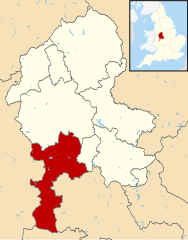
Położenie na mapie Staffordshire | |
| Strona internetowa | |
| Portal | |
South Staffordshire – dystrykt w hrabstwie Staffordshire w Anglii. W 2011 roku dystrykt liczył 108 131 mieszkańców[1].
Miasta
- Penkridge
Inne miejscowości
Acton Trussell, Ashwood, Bilbrook, Bishops Wood, Blymhill, Bobbington, Bratch, Brewood, Brewood and Coven, Cheslyn Hay, Codsall, Coven, Enville, Essington, Featherstone, Four Ashes (Brewood and Coven), Four Ashes (Enville), Gailey, Gospel End, Great Wyrley, Greensforge, Himley, Huntington, Kinver, Landywood, Lapley, Lower Penn, Newtown, Orslow, Orton, Pattingham, Perton, Saredon, Seisdon, Swindon, Trysull, Weston-under-Lizard, Wheaton Aston, Wombourne.
Przypisy
- ↑ Area: South Staffordshire (Local Authority) (ang.). Neighbourhood Statistics (ONS). [dostęp 2016-04-24]. [zarchiwizowane z tego adresu (2016-10-03)].
Media użyte na tej stronie
Flag of England. Saint George's cross (a red cross on a white background), used as the Flag of England, the Italian city of Genoa and various other places.
(c) John M, CC BY-SA 2.0
South Staffordshire Council Offices, Codsall, Staffordshire, England. 1970s offices housing the local district council.
Autor:
- Staffordshire UK district map (blank).svg: Nilfanion, created using Ordnance Survey data
- derivative work: Renly (talk)
Map of Staffordshire, with South Staffordshire highlighted.


