Strömsholm
 | |
| Państwo | |
|---|---|
| Region | |
| Gmina | |
| Powierzchnia | 1,26[1] km² |
| Populacja (2018) • liczba ludności • gęstość | |
| Portal | |
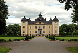
Strömsholm – miejscowość (tätort) w Szwecji w gminie Hallstahammar w regionie Västmanland nad jeziorem Melar. Około 594 mieszkańców[2]. Na południe od miejscowości mieści się zamek Strömsholm, jeden z dziesięciu zamków królewskich w Szwecji.
Przypisy
- ↑ a b c Statistiska tätorter 2018; befolkning, landareal, befolkningstäthet. Statistikmyndigheten SCB, 2020-03-20. [dostęp 2020-09-08]. [zarchiwizowane z tego adresu (2020-03-24)]. (szw.).
- ↑ Szwedzki Urząd Statystyczny SCB. [dostęp 2010-01-11]. (szw.).
Media użyte na tej stronie
(c) Lokal_Profil, CC BY-SA 2.5
This coat of arms was drawn based on its blazon which – being a written description – is free from copyright. Any illustration conforming with the blazon of the arms is considered to be heraldically correct. Thus several different artistic interpretations of the same coat of arms can exist. The design officially used by the armiger is likely protected by copyright, in which case it cannot be used here.
Individual representations of a coat of arms, drawn from a blazon, may have a copyright belonging to the artist, but are not necessarily derivative works.
Autor: Tomasz Zugaj, Licencja: CC BY-SA 4.0
Zamek królewski w Strömsholm
Autor: Erik Frohne, Licencja: CC BY 3.0
Location map of Västmanland in Sweden
Equirectangular projection, N/S stretching 199 %. Geographic limits of the map:
- N: 60.30° N
- S: 59.10° N
- W: 15.30° E
- E: 17.10° E


