Street (Mendip)
 Friends' Meeting House | |
| Państwo | |
|---|---|
| Kraj | |
| Region | |
| Hrabstwo | |
| Dystrykt | |
| Populacja (2001) • liczba ludności |
|
| Nr kierunkowy | 01458 |
| Kod pocztowy | BA16 |
Położenie na mapie Somersetu  Contains Ordnance Survey data © Crown copyright and database right, CC BY-SA 3.0 | |
Położenie na mapie Wielkiej Brytanii  (c) Karte: NordNordWest, Lizenz: Creative Commons by-sa-3.0 de | |
Położenie na mapie Anglii  | |
| Strona internetowa | |
| Portal | |
Street – wieś i civil parish w południowo-zachodniej Anglii, w hrabstwie Somerset, w dystrykcie Mendip[1]. Położone jest na równinie Somerset Levels na końcu wzgórz Polden Hills, trzy kilometry na zachód od Glastonbury. W 2001 roku wieś liczyła 11 066 mieszkańców[2].
Na obrzeżach miejscowości działają znane szkoły, m.in. koedukacyjna niezależna (ang. independent school) szkoła z internatem, założona przez Jacka Meyera (1991–1905), pedagoga i krykiecistę. Nosi nazwę Millfield[3]. Jest jedną z pięciu brytyjskich szkół należących do stowarzyszenia „G20 Schools”[4][5]. Wraz ze szkołą przygotowawczą ma ok. 1700 uczniów i zatrudnia 600 pracowników[6].
Historia
Ośrodek istniał już w średniowieczu pod nazwą Lantokay, w Domesday Book z roku 1086 wymieniony pod nazwą Lega[7], istniejące dziś w formie Leigh. W czasach nowożytnych słynął z produkcji obuwia[8]. Firma C&J Clark, która była najprężniejsza w tej dziedzinie, istnieje do dziś i dotąd ma siedzibę w Street, choć nie produkuje się tu obuwia[9]. W 1935 roku Rollo John Oliver Meyer[10] („Jack”, „Boss”) w wynajętym od rodziny Clark[11] „Millfield House” uruchomił szkołę. Pierwszymi uczniami było siedmiu indyjskich chłopców, z którymi wrócił z Indii (sześciu z nich było książętami)[6].

Popiersie założyciela szkoły Millfield
Rozmieszczenie obiektów szkolnych

„Millfield House”

Nowy budynek matematyki

Szkolne boisko do krykieta
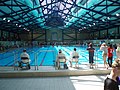
50-metrowy szkolny basen olimpijski
Przypisy
- ↑ Street. Ordnance Survey linked data. [dostęp 2016-09-22]. (ang.).
- ↑ Somerset County Council: Parish Population Statistics. WebCite. [dostęp 2010-10-08]. (ang.).
- ↑ Gavin Horgan (headmaster): Welcome to Millfield. [w:] Strona internetowa szkoły Millfield [on-line]. [dostęp 2019-09-03]. (ang.).
- ↑ Countries With G20 Schools. [w:] worldatlas [on-line]. [dostęp 2019-09-03]. (ang.).
- ↑ G20 Education Ministers’ Declaration 2018 Building consensus for fair and sustainable development. Unleashing people’s potential.. [w:] G20 Education Ministerial Meeting. [on-line]. 5 September 2018. s. 1-8. [dostęp 2019-09-03]. [zarchiwizowane z tego adresu (2019-09-03)]. (ang.).
- ↑ a b Our History. [w:] Strona internetowa Millfield [on-line]. Millfield. [dostęp 2019-09-04]. (ang.).
- ↑ The Domesday Book - Life in 11th Century England. [dostęp 2008-09-18]. [zarchiwizowane z tego adresu (2008-05-13)]. (ang.).
- ↑ Street. [dostęp 2008-09-18]. [zarchiwizowane z tego adresu (2008-08-03)]. (ang.).
- ↑ Street CP High Street. [dostęp 2008-09-18]. [zarchiwizowane z tego adresu (2012-10-06)]. (ang.).
- ↑ Peter Kemp: Meyer, Rollo John Oliver [Jack]. [w:] Oxford DNB [on-line]. Oxford University Press. [dostęp 2019-09-04]. (ang.).
- ↑ Lancelot Clark: “If you teach your workers well, it is good for business”. [w:] The Bi9g Issue; Social Enterprise [on-line]. The Big Issue Company Ltd. [dostęp 2019-09-04]. (ang.).
Media użyte na tej stronie
Contains Ordnance Survey data © Crown copyright and database right, CC BY-SA 3.0
Map of Somerset, UK with the following information shown:
- Administrative borders
- Coastline, lakes and rivers
- Roads and railways
- Urban areas
Equirectangular map projection on WGS 84 datum, with N/S stretched 155%
Geographic limits:
- West: 3.96W
- East: 2.12W
- North: 51.55N
- South: 50.80N
(c) Karte: NordNordWest, Lizenz: Creative Commons by-sa-3.0 de
Location map of the United Kingdom


Flag of England. Saint George's cross (a red cross on a white background), used as the Flag of England, the Italian city of Genoa and various other places.

(c) Bjrobinson z angielskojęzycznej Wikipedii, CC-BY-SA-3.0
. Taken by me in the course of my job, seemed useful to show how impressive the facilities are.


Autor: Brookie, Licencja: CC BY-SA 3.0
The new maths block at Millfield school, England

Autor: Brookie, Licencja: CC BY-SA 3.0
Millfield House, Millfield School in Street in Somerset, England.
Friends (Quaker) Meeting House, in Street, Somerset, UK. The village found prosperity when two Quaker brothers, Cyrus and James Clark, founded a shoe company in en:1825 which continues to this day.
Picture taken by wurzeller on 06 May 2005 and hereby released into en:public domain


Autor: Harrias, Licencja: CC BY-SA 3.0
Main cricket ground at Millfield School, showing the pavilion. Note the tree on the right hand side of the image, which is within the boundary. The match is being played between a Millfield XI and Somerset County Cricket Club's Second XI.