Sunne
 | |
| Państwo | |
|---|---|
| Region | |
| Gmina | |
| Powierzchnia | 5,23[1] km² |
| Wysokość | 125 m n.p.m. |
| Populacja (2018) • liczba ludności • gęstość | |
Położenie na mapie Värmlandu  | |
Położenie na mapie Szwecji  | |
| Portal | |
Sunne – szwedzkie miasto położone w środkowej części regionu Värmland, w gminie Sunne. Leży u stóp szwedzkiej części Gór Skandynawskich, w pobliżu granicy z Norwegią. Sunne jest siedzibą gminy o tej samej nazwie. Według ostatniego spisu mieszkańców mieszkają tam 4903 osoby.
Sunne jest ośrodkiem narciarskim. Znajduje się tu 18 tras obsługiwanych przez 7 wyciągów. W przeszłości rozgrywano tutaj zawody Pucharu Świata w biegach narciarskich.
Ludzie związani z Sunne:
- Sven-Göran Eriksson – piłkarz i trener,
- Helene Tursten – pisarka,
- Anders Fryxell – historyk,
- Ana Johnsson – piosenkarka.
Galeria

Sunne
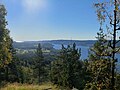
Jezioro Rottnen w pobliżu Sunne

Kościół w Sunne

Posąg Selmy Lagerlöf w Sunne
Przypisy
- ↑ a b c Statistiska tätorter 2018; befolkning, landareal, befolkningstäthet. Statistikmyndigheten SCB, 2020-03-20. [dostęp 2020-09-08]. [zarchiwizowane z tego adresu (2020-03-24)]. (szw.).
Linki zewnętrzne
Media użyte na tej stronie


Värmland vapen.svg
(c) Lokal_Profil, CC BY-SA 2.5
This coat of arms was drawn based on its blazon which – being a written description – is free from copyright. Any illustration conforming with the blazon of the arms is considered to be heraldically correct. Thus several different artistic interpretations of the same coat of arms can exist. The design officially used by the armiger is likely protected by copyright, in which case it cannot be used here.
Individual representations of a coat of arms, drawn from a blazon, may have a copyright belonging to the artist, but are not necessarily derivative works.
Sunnesundet.jpg
The sound Sunnesundet and Sunne church
The sound Sunnesundet and Sunne church

Selma Lagerlof statue Sunne.jpg
Autor: Vogler, Licencja: CC BY-SA 3.0
Statue of the writer Selma Lagerlöf in Sunne, Sweden.
Autor: Vogler, Licencja: CC BY-SA 3.0
Statue of the writer Selma Lagerlöf in Sunne, Sweden.

Sunnekyrka1.jpg
Sunne church in Värmland, Sweden.
Sunne church in Värmland, Sweden.
Sweden Värmland location map.svg
Autor: Erik Frohne, Licencja: CC BY 3.0
Location map of Värmland in Sweden
Autor: Erik Frohne, Licencja: CC BY 3.0
Location map of Värmland in Sweden
Equirectangular projection, N/S stretching 199 %. Geographic limits of the map:
- N: 61.20° N
- S: 58.60° N
- W: 11.60° E
- E: 14.70° E

Rottnen2.jpg
View over lake Rottnen nearest and lake Fryken from Gettjärnsklätten, Sunne, Värmland, Sweden.
View over lake Rottnen nearest and lake Fryken from Gettjärnsklätten, Sunne, Värmland, Sweden.