Szilo
| ||
 | ||
| Państwo | / | |
| Wysokość | 700 m n.p.m. | |
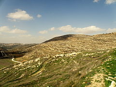
Szilo (hebr. שילה) – starożytne miasto. W czasach biblijnych w świątyni w Szilo przechowywano Arkę Przymierza. Dziś identyfikuje się ono z miejscowością Chirbet Selun, 16 km na północ od Bet El na Zachodnim Brzegu Jordanu[1].

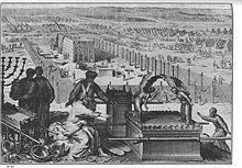
Cała społeczność Izraelitów zgromadziła się w Szilo i wzniesiono tam Namiot Spotkania.
Przypisy
Media użyte na tej stronie
Flag of Israel. Shows a Magen David (“Shield of David”) between two stripes. The Shield of David is a traditional Jewish symbol. The stripes symbolize a Jewish prayer shawl (tallit).
The erection of the Tabernacle and the Sacred vessels, as in Exodus 40:17-19, "And it came to pass in the first month in the second year, on the first day of the month, that the tabernacle was reared up. And Moses reared up the tabernacle, and fastened his sockets, and set up the boards thereof, and put in the bars thereof, and reared up his pillars. And he spread abroad the tent over the tabernacle, and put the covering of the tent above upon it; as the Lord commanded Moses."; illustration from the 1728 Figures de la Bible; illustrated by Gerard Hoet (1648–1733) and others, and published by P. de Hondt in The Hague; image courtesy Bizzell Bible Collection, University of Oklahoma Libraries
Autor: RonAlmog from Israel (ישראל), Licencja: CC BY 2.0
תל שילה
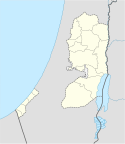
Autor: NordNordWest, Licencja: CC BY-SA 3.0
Location map of the Palestinian territories (West Bank and Gaza Strip)


