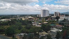
Tagaytay
| ||
 | ||
| Państwo | ||
| Region | CALABARZON | |
| Prowincja | Cavite | |
| Prawa miejskie | 1945 | |
| Burmistrz | Abraham „Bambol” Tolentino | |
| Powierzchnia | 66,1 km² | |
| Wysokość | 230 m n.p.m. | |
| Populacja (2007) • liczba ludności • gęstość | 61 623 932 os./km² | |
| Nr kierunkowy | 46 | |
| Kod pocztowy | 4120 | |
| Strona internetowa | ||
Tagaytay – miasto na Filipinach, w prowincji Cavite, na wyspie Luzon. W 2007 liczyło 61 623 mieszkańców.
Miasta partnerskie
 Amman, Jordania
 Bacolod, Filipiny
 Cuernavaca, Meksyk
 Daraga, Filipiny
 Fukuoka, Japonia
 Goulbourn, Kanada
 Iriga, Filipiny
 Las Vegas, Stany Zjednoczone
 City of Manningham, Australia
 Palayan, Filipiny
 Tainan, Republika Chińska
Linki zewnętrzne
Media użyte na tej stronie
Flag of the United States.svg
The flag of Navassa Island is simply the United States flag. It does not have a "local" flag or "unofficial" flag; it is an uninhabited island. The version with a profile view was based on Flags of the World and as a fictional design has no status warranting a place on any Wiki. It was made up by a random person with no connection to the island, it has never flown on the island, and it has never received any sort of recognition or validation by any authority. The person quoted on that page has no authority to bestow a flag, "unofficial" or otherwise, on the island.
The flag of Navassa Island is simply the United States flag. It does not have a "local" flag or "unofficial" flag; it is an uninhabited island. The version with a profile view was based on Flags of the World and as a fictional design has no status warranting a place on any Wiki. It was made up by a random person with no connection to the island, it has never flown on the island, and it has never received any sort of recognition or validation by any authority. The person quoted on that page has no authority to bestow a flag, "unofficial" or otherwise, on the island.
Tagaytay skyline 2019.jpg
Autor: Hariboneagle927, Licencja: CC BY-SA 3.0
View of buildings in Tagaytay from the Sky Eye ferris wheel.
Autor: Hariboneagle927, Licencja: CC BY-SA 3.0
View of buildings in Tagaytay from the Sky Eye ferris wheel.
Philippines location map.svg
Autor: NordNordWest, Licencja: CC BY 3.0
Location map of the Philippines
Autor: NordNordWest, Licencja: CC BY 3.0
Location map of the Philippines


