Tamilnadu
| stan | |||
 | |||
| |||
| Państwo | |||
|---|---|---|---|
| Siedziba | |||
| Kod ISO 3166-2 | IN-TN | ||
| Gubernator | Banwarilal Purohit | ||
| Premier | Edappadi K. Palaniswami | ||
| Powierzchnia | 130 058 km² | ||
| Populacja (2011) • liczba ludności |
| ||
| • gęstość | 554,7 os./km² | ||
| Języki urzędowe | |||
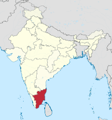
Położenie na mapie Indii | |||
| Strona internetowa | |||
Tamilnadu (tamilski தமிழ்நாடு; ang. Tamil Nadu; hindi तमिल नाडु, trb.: Tamilnad, trl.: Tamiḻ Nāṭu) – jeden ze stanów Indii, położony w ich południowej części, zamieszkany głównie przez Tamilów, lud pochodzenia drawidyjskiego[2].
Stolicą stanu, a zarazem największym miastem jest Ćennaj[3].
Stan został utworzony 18 lipca 1967[4].
Geografia
Powierzchnia stanu Tamilnadu wynosi 130 058 km², co czyni go jedenastym pod względem wielkości stanem Indii[5]. Na zachodzie graniczy ze stanem Kerala, na północnym zachodzie z Karnataką oraz na północy z Andhra Pradesh[6]. Na wschodzie znajduje się Zatoka Bengalska oraz terytorium związkowe Puducherry[6]. Na terenie stanu znajduje się również najbardziej na południe wysunięty punkt półwyspu Indyjskiego – miasto Kanyakumari, gdzie spotykają się wody Morza Arabskiego, Zatoki Bengalskiej i Oceanu Indyjskiego[7][5].
Podział administracyjny
Stan Tamilnadu dzieli się na następujące dystrykty[5]:
Zobacz też
- Miasta Tamilnadu
Przypisy
- ↑ 2011 Census of India, censusindia.gov.in [dostęp 2019-08-02] [zarchiwizowane z adresu 2019-05-31].
- ↑ Południowy cypel Indii. Niezwykły stan Tamil Nadu, podroze.dziennik.pl, 18 czerwca 2011 [dostęp 2020-04-04] (pol.).
- ↑ Ćennaj (Madras) – niezwykły, choć mało znany fragment Indii, dziendobry.tvn.pl, 3 grudnia 2019 [dostęp 2020-04-04] (pol.).
- ↑ R. Muthukamar, From Madras to Tamil Nadu: a forgotten re-naming, www.madrasmusings.com [dostęp 2020-04-04].
- ↑ a b c Tamil Nadu, Department of International Trade Promotion [dostęp 2020-04-04] (ang.).
- ↑ a b India States and Union Territories, hciseychelles.gov.in (ang.).
- ↑ Kanniyakumari, [w:] Encyclopædia Britannica [online] [dostęp 2020-04-04] (ang.).
Linki zewnętrzne
Media użyte na tej stronie
The Flag of India. The colours are saffron, white and green. The navy blue wheel in the center of the flag has a diameter approximately the width of the white band and is called Ashoka's Dharma Chakra, with 24 spokes (after Ashoka, the Great). Each spoke depicts one hour of the day, portraying the prevalence of righteousness all 24 hours of it.
Emblem of the State Government of Tamil Nadu used by the state government for public notices in the press and for publicity purposes. The emblem of India is the image used on the India Wikipedia article.
Autor: TUBS
Location of state XY (see filename) in India
Autor: எஸ்ஸார், Licencja: CC BY-SA 3.0
Photos used in this collage image depicting some genre. From top Left: One of the Landmark that represents Tamil Nadu (Chennai Central), Tamil Culture (Bull tamming), Tamil Historical monument (Tanjore Big temple), Education in Tamil Nadu (Guindy campus of Anna University), Geography of Tamil Nadu (a beach at Tiruchendur), cuisines of Tamil Nadu (Idly-Vada), Arts (Bharatanatyam) and Tamil Legend Thiruvalluvar (Tiruvalluvar Statue at the southern end of Indian Peninsula). Images used from Commons.
Autor: BishkekRocks (talk); original file: User:SwiftRakesh, Licencja: CC BY-SA 3.0
Districts of Tamil Nadu, numbered
- Ariyalur District
- Chennai District (M)
- Coimbatore District
- Cuddalore District
- Dharmapuri District
- Dindigul District
- Erode District
- Kanchipuram District
- Kanyakumari District
- Karur District
- Krishnagiri District
- Madurai District
- Nagapattinam District
- Namakkal District
- Nilgiris District
- Perambalur District
- Pudukkottai District
- Ramanathapuram District
- Salem District
- Sivagangai District
- Thanjavur District
- Theni District
- Thoothukudi District
- Thiruchirapalli District
- Thirunelveli District
- Tiruppur district
- Thiruvallur District
- Thiruvannamalai District
- Thiruvarur District
- Vellore District
- Viluppuram District
- Virudhunagar District


