Tennessee (rzeka)
 | |
| Kontynent | Ameryka Północna |
|---|---|
| Państwo | |
| Rzeka | |
| Długość | 1049 km |
| Źródło | |
| Współrzędne | 35°57′33,3″N 83°51′00,7″W/35,959251 -83,850181 |
| Ujście | |
| Recypient | Ohio |
| Miejsce | Paducah, Kentucky |
| Współrzędne | 37°04′02,2″N 88°33′53,2″W/37,067279 -88,564769 |
| Mapa | |
 | |
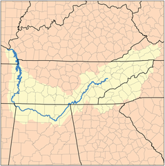
Tennessee – rzeka w Stanach Zjednoczonych, główny dopływ rzeki Ohio. Przepływa przez stany Tennessee, Alabama, Kentucky i Missisipi. Część Tennessee znajduje się w Równinach Centralnych, druga część w Appalachach[1].
Zobacz też
Przypisy
- ↑ Tennessee River. W: Geographic Names Information System (GNIS) [on-line]. United States Geological Survey, 20 września 1979. [dostęp 2014-03-29].
Media użyte na tej stronie
Autor: Uwe Dedering, Licencja: CC BY-SA 3.0
Relief location map of the USA (without Hawaii and Alaska).
EquiDistantConicProjection : Central parallel :
* N: 37.0° N
Central meridian :
* E: 96.0° W
Standard parallels:
* 1: 32.0° N
* 2: 42.0° N
Made with Natural Earth. Free vector and raster map data @ naturalearthdata.com.
Formulas for x and y:
x = 50.0 + 124.03149777329222 * ((1.9694462586094064-({{{2}}}* pi / 180))
      * sin(0.6010514667026994 * ({{{3}}} + 96) * pi / 180))
y = 50.0 + 1.6155950752393982 * 124.03149777329222 * 0.02613325650382181
      - 1.6155950752393982  * 124.03149777329222 *
     (1.3236744353715044  - (1.9694462586094064-({{{2}}}* pi / 180))
      * cos(0.6010514667026994 * ({{{3}}} + 96) * pi / 180))
The flag of Navassa Island is simply the United States flag. It does not have a "local" flag or "unofficial" flag; it is an uninhabited island. The version with a profile view was based on Flags of the World and as a fictional design has no status warranting a place on any Wiki. It was made up by a random person with no connection to the island, it has never flown on the island, and it has never received any sort of recognition or validation by any authority. The person quoted on that page has no authority to bestow a flag, "unofficial" or otherwise, on the island.
Autor: Autor nie został podany w rozpoznawalny automatycznie sposób. Założono, że to Kmusser (w oparciu o szablon praw autorskich)., Licencja: CC BY-SA 2.5
This is a map of the Tennessee River Watershed. I, Karl Musser, created it based on USGS data.
Taken by Mark Daily on June 29, 2004 with a HP digital camera.


