Tuntange
| |||
| gmina | |||
 Kościół w mieście | |||
| |||
| Państwo | |||
|---|---|---|---|
| Dystrykt | Luksemburg | ||
| Kanton | Mersch | ||
| Powierzchnia | 18,74 km² | ||
| Populacja (2005) • liczba ludności | 1 064 | ||
| • gęstość | 56,78 os./km² | ||
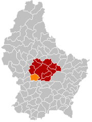
Położenie na mapie Luksemburga | |||
Tuntange − gmina i miasteczko w centralnym Luksemburgu, w dystrykcie Luksemburg, w kantonie Mersch.
W 2005 roku, miasto Tuntange, które znajduje się w zachodniej części gminy, zamieszkiwało 1000 osób. Inne miejscowości w gminie: Hollenfels oraz Marienthal.
Media użyte na tej stronie
Autor: Cayambe, Licencja: CC BY-SA 3.0
Platanus sp., Plane tree, close to the entry of the church in Tuntange, Luxembourg (country). This tree is ranked with the "Remarkable trees in Luxembourg".
Autor: User:Commune de Tuntange, Licencja: CC-BY-SA-3.0
Coat of arms of the municipality of Tuntange, Luxembourg


