United States Postal Service
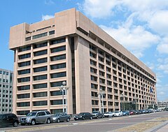
siedziba USPS | |
| Państwo | |
|---|---|
| Data utworzenia | 1 lipca 1971 |
| Siedziba | |
| Poczmistrz generalny | Louis DeJoy |
| Strona internetowa | |
United States Postal Service (USPS) – niezależna agencja Rządu Stanów Zjednoczonych, utworzona w 1971 r., jako „niezależna placówka władzy wykonawczej”. Jest jedną z niewielu agencji, której upoważnienie wynika bezpośrednio z Konstytucji Stanów Zjednoczonych. Faktycznie, powstała w 1775 r., jako United States Post Office (U.S.P.O.), w wyniku postanowień Drugiego Kongresu Kontynentalnego.
Odpowiada za świadczenie usług pocztowych wszystkim obywatelom Stanów Zjednoczonych, bez względu na położenie i z zapewnieniem im jednolitej ceny i jakości usług. Zatrudnia ok. 600 tysięcy pracowników[1], co czyni ją drugim co do wielkości cywilnym pracodawcą w Stanach Zjednoczonych (po Walmart) i dysponuje flotą ponad 212 530 pojazdów[2], w wyniku czego jest największym na świecie operatorem taboru samochodowego.
Przypisy
- ↑ Amerykańska poczta ma problemy przez koronawirusa. W tle Amazon i Biały Dom, www.rp.pl [dostęp 2021-03-09] (pol.).
- ↑ U.S. Postal Service: Postal Facts 2013 (ang.). 2013. [dostęp 2014-01-18].
Bibliografia
- Understanding the Private Express Statutes USPS Publication 542 (Czerwiec 1998)
Linki zewnętrzne
Media użyte na tej stronie
Autor: Alexrk2, Licencja: CC BY 3.0
Ta mapa została stworzona za pomocą GeoTools.
Autor: Uwe Dedering, Licencja: CC BY-SA 3.0
Location map of the USA (without Hawaii and Alaska).
EquiDistantConicProjection:
Central parallel:
* N: 37.0° N
Central meridian:
* E: 96.0° W
Standard parallels:
* 1: 32.0° N
* 2: 42.0° N
Made with Natural Earth. Free vector and raster map data @ naturalearthdata.com.
Formulas for x and y:
x = 50.0 + 124.03149777329222 * ((1.9694462586094064-({{{2}}}* pi / 180))
      * sin(0.6010514667026994 * ({{{3}}} + 96) * pi / 180))
y = 50.0 + 1.6155950752393982 * 124.03149777329222 * 0.02613325650382181
      - 1.6155950752393982  * 124.03149777329222 *
     (1.3236744353715044  - (1.9694462586094064-({{{2}}}* pi / 180))
      * cos(0.6010514667026994 * ({{{3}}} + 96) * pi / 180))
The flag of Navassa Island is simply the United States flag. It does not have a "local" flag or "unofficial" flag; it is an uninhabited island. The version with a profile view was based on Flags of the World and as a fictional design has no status warranting a place on any Wiki. It was made up by a random person with no connection to the island, it has never flown on the island, and it has never received any sort of recognition or validation by any authority. The person quoted on that page has no authority to bestow a flag, "unofficial" or otherwise, on the island.
(c) Coolcaesar at en.wikipedia, CC BY-SA 3.0
United States Postal Service headquarters at L'Enfant Plaza in Washington, D.C. It was designed by architect Vlastimil Koubek.


