University of West London
 Kampus w dzielnicy Brentford | |
| Data założenia | 1991 |
|---|---|
| Typ | publiczna |
| Państwo | |
| Kraj | |
| Adres | Saint Mary's Road, Ealing, London W5 5RF |
| Liczba studentów | 47.430[1] |
| Rektor | Laurence Geller |
Położenie na mapie gminy Ealing  Contains Ordnance Survey data © Crown copyright and database right, CC BY-SA 3.0 | |
Położenie na mapie Wielkiej Brytanii  (c) Karte: NordNordWest, Lizenz: Creative Commons by-sa-3.0 de | |
Położenie na mapie Anglii  | |
Położenie na mapie Wielkiego Londynu  Contains Ordnance Survey data © Crown copyright and database right, CC BY-SA 3.0 | |
| Strona internetowa | |
University of West London (dawniej Thames Valley University) – publiczny uniwersytet w Londynie w Wielkiej Brytanii. Ma kampusy w londyńskich dzielnicach Ealing i Brentford oraz w nieodległym mieście Reading.
Historia
Uczelnia ma korzenie w 1860, kiedy została założona Lady Byron School. Placówka zmieniła następnie nazwę na Ealing College of Higher Education. W 1990 Ealing College of Higher Education, Thames Valley College of Higher Education, Queen Charlotte's College of Health Care Studies i London College of Music połączyły się tworząc Polytechnic of West London. W 1992 politechnika została przekształcona w uniwersytet i otrzymała nazwę Thames Valley University. W 2004 połączyła się z Reading College and School of Arts and Design.
W sierpniu 2010 podano do wiadomości, że uniwersytet uzyskał zgodę na zmianę nazwy na University of West London, dla podkreślenia działalność w ośrodkach Ealing i Brentford. Nowa nazwa została formalnie wprowadzona 6 kwietnia 2011[2].
Struktura
W skład uniwersytetu wchodzą następujące szkoły i kolegia:
- Ealing Law School (szkoła prawa),
- Ealing School of Art, Design and Media (szkoła sztuki, projektowania i mediów),
- London College of Music (kolegium muzyczne),
- College of Nursing, Midwifery and Healthcare (kolegium pielęgniarstwa, położnictwa i opieki zdrowotnej),
- London School of Hospitality and Tourism (szkoła hotelarstwa i gastronomii),
- School of Computing and Technology (szkoła informatyki),
- School of Psychology, Social Work and Human Sciences (szkoła psychologii, pracy socjalnej i nauk humanistycznych),
- West London Business School (szkoła biznesu).
Działalność dydaktyczna
Uniwersytet prowadzi studia umożliwiające otrzymanie m.in. takich tytułów jak:
Galeria

Kampus uniwersytetu przy St Mary's Road w dzielnicy Ealing

Walpole House w dzielnicy Ealing - siedziba administracji uniwersytetu
 (c) David Hawgood, CC BY-SA 2.0
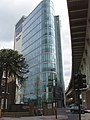
Kampus uniwersytetu w dzielnicy Brentford
Przypisy
- ↑ Table 0a - All students by institution, mode of study, level of study, gender and domicile 2006/07. [dostęp 2016-08-20]. [zarchiwizowane z tego adresu (2016-08-20)].
- ↑ Ealing University's name change stalled. [dostęp 2012-07-25]. [zarchiwizowane z tego adresu (2012-03-14)].
Media użyte na tej stronie
(c) Karte: NordNordWest, Lizenz: Creative Commons by-sa-3.0 de
Location map of the United Kingdom
Contains Ordnance Survey data © Crown copyright and database right, CC BY-SA 3.0
Map of Greater London, UK with the following information shown:
- Administrative borders
- Coastline, lakes and rivers
- Roads and railways
- Urban areas
The data includes both primary routes and railway lines.
Equirectangular map projection on WGS 84 datum, with N/S stretched 160%
Geographic limits:
- West: 0.57W
- East: 0.37E
- North: 51.72N
- South: 51.25N


Flag of England. Saint George's cross (a red cross on a white background), used as the Flag of England, the Italian city of Genoa and various other places.


(c) David Hawgood, CC BY-SA 2.0
Thames Valley University Paragon campus, building by the M4 This TVU building is very noticeable from the elevated M4 - and very close to it. TVU has some plainer blocks of student accommodation on the site. See TVU Paragon page http://www.health.tvu.ac.uk/news/paragon.asp. There are also apartments for sale at the site, see http://www.paragon-homes.co.uk/ .
The Thames Valley University (TVU) Paragon Campus in Brentford, London.

The Thames Valley University (TVU) campus at St Mary's Road, Ealing, London.
Contains Ordnance Survey data © Crown copyright and database right, CC BY-SA 3.0
Blank map of the London Borough of Ealing, showing electoral wards used from 2002 to 2022.
Equirectangular map projection on WGS 84 datum, with N/S stretched 160%
Geographic limits:
- West: 0.425W
- East: 0.24W
- North: 51.565N
- South: 51.485N

The Thames Valley University (TVU) Walpole House in Ealing, London.