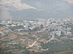
Urif
| ||
 | ||
| Państwo | / | |
|---|---|---|
| Muhafaza | Nablus | |
| Populacja (2016) • liczba ludności | 3545 | |
Urif (arab. عوريف, ʿŪrīf) – wieś w Palestynie, w muhafazie Nablus. Według danych szacunkowych Palestyńskiego Centralnego Biura Statystycznego w 2016 roku miejscowość liczyła 3545 mieszkańców[1].
Przypisy
- ↑ Localities in Nablus Governorate by Type of Locality and Population Estimates, 2007–2016 (ang.). Palestinian Central Bureau of Statistics. [dostęp 2018-12-02].
Media użyte na tej stronie
Flag of Israel. Shows a Magen David (“Shield of David”) between two stripes. The Shield of David is a traditional Jewish symbol. The stripes symbolize a Jewish prayer shawl (tallit).
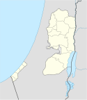
Map of the Palestinian Authorities showing the Governate of Nablus
Autor: NordNordWest, Licencja: CC BY-SA 3.0
Location map of the Palestinian territories (West Bank and Gaza Strip)


