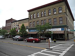
Watkins Glen (Nowy Jork)
 Centrum Watkins Glen | |
| Państwo | |
|---|---|
| Stan | |
| Hrabstwo | |
| Powierzchnia | 5,0[1] km² |
| Populacja (2010) • liczba ludności • gęstość |
|
| Kod pocztowy | 14891 |
Położenie na mapie stanu Nowy Jork (c) NordNordWest, CC BY 3.0 | |
| Strona internetowa | |
| Portal | |
Watkins Glen – wieś (village), ośrodek administracyjny hrabstwa Schuyler, w środkowej części stanu Nowy Jork, w Stanach Zjednoczonych, położona na południowym skraju jeziora Seneca[3]. W 2010 roku miejscowość liczyła 1859 mieszkańców[2].
Pierwsi osadnicy przybyli tu w 1791 roku. Oficjalne założenie wsi, nazwanej wówczas Jefferson, nastąpiło w 1842 roku. W 1852 roku przyjęta została nazwa Watkins, upamiętniająca jednego z założycieli, a w 1926 roku obecna – Watkins Glen[3].
Na zachód od miejscowości znajduje się park stanowy Watkins Glen, obejmujący wąwóz, którego dnem spływa potok Glen Creek, tworząc kaskady i bystrza. W pobliżu zlokalizowany jest również samochodowy tor wyścigowy Watkins Glen International[3].
Przypisy
- ↑ 2015 U.S. Gazetteer Files: Places: New York. US Census Bureau. [dostęp 2018-05-10]. (ang.).
- ↑ a b Watkins Glen village, New York. American FactFinder – US Census Bureau. [dostęp 2018-05-10]. [zarchiwizowane z tego adresu (2015-01-18)]. (ang.).
- ↑ a b c Watkins Glen, [w:] Encyclopædia Britannica [online] [dostęp 2018-05-10] (ang.).
Media użyte na tej stronie
(c) NordNordWest, CC BY 3.0
Location map of the State of New York, USA
Autor: Uwe Dedering, Licencja: CC BY-SA 3.0
Location map of the USA (without Hawaii and Alaska).
EquiDistantConicProjection:
Central parallel:
* N: 37.0° N
Central meridian:
* E: 96.0° W
Standard parallels:
* 1: 32.0° N
* 2: 42.0° N
Made with Natural Earth. Free vector and raster map data @ naturalearthdata.com.
Formulas for x and y:
x = 50.0 + 124.03149777329222 * ((1.9694462586094064-({{{2}}}* pi / 180))
      * sin(0.6010514667026994 * ({{{3}}} + 96) * pi / 180))
y = 50.0 + 1.6155950752393982 * 124.03149777329222 * 0.02613325650382181
      - 1.6155950752393982  * 124.03149777329222 *
     (1.3236744353715044  - (1.9694462586094064-({{{2}}}* pi / 180))
      * cos(0.6010514667026994 * ({{{3}}} + 96) * pi / 180))
The flag of Navassa Island is simply the United States flag. It does not have a "local" flag or "unofficial" flag; it is an uninhabited island. The version with a profile view was based on Flags of the World and as a fictional design has no status warranting a place on any Wiki. It was made up by a random person with no connection to the island, it has never flown on the island, and it has never received any sort of recognition or validation by any authority. The person quoted on that page has no authority to bestow a flag, "unofficial" or otherwise, on the island.
Autor: Dmadeo, Licencja: CC BY-SA 3.0
Watkins Glen Commercial Historic District


