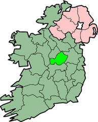
Westmeath
| hrabstwo | |||||
| |||||
| Państwo | |||||
|---|---|---|---|---|---|
| Prowincja | Leinster | ||||
| Siedziba | Mullingar | ||||
| Powierzchnia | 1764 km² | ||||
| Populacja (2011) • liczba ludności | 86 164[1] | ||||
| • gęstość | 48,85 os./km² | ||||
| Tablice rejestracyjne | WH | ||||
Położenie na mapie Irlandii | |||||
| Strona internetowa | |||||
Westmeath (irl. Contae na hIarmhí) – hrabstwo w środkowej Irlandii, w zachodniej części prowincji Leinster. Hrabstwo było częścią dawnego królestwa Meath, a potem hrabstwa Meath, ten stan zakończył się w roku 1543, kiedy zostało utworzone hrabstwo Westmeath.
Największym miastem hrabstwa jest Athlone, leżące nad rzeką Shannon, podczas gdy Mullingar jest administracyjnym centrum hrabstwa.
Hrabstwo jest znane ze swojego bydła, jezior (np. Lough Owel), stopu cyny z ołowiem (Mullingar Pewter), scenerii, kanału i firmy farmaceutycznej Elán.
Miasta i wioski
- Athlone
- Castlepollard
- Castletown-Geoghegan
- Collinstown
- Delvin
- Fore
- Finnea
- Glasson
- Horseleap
- Kilbeggan
- Killucan
- Kinnegad
- Moate
- Mullingar
- Multyfarnham
- Raharney
- Rochfortbridge
- Tyrrellspass
Westmeath sąsiaduje z hrabstwami: Cavan, Longford, Meath, Offaly i Roscommon.
Przypisy
- ↑ Census 2011 Population Classified by Area (ang.). [dostęp 2012-10-20].
Media użyte na tej stronie
Autor: CeltBrowne, Licencja: CC BY-SA 4.0
The Coat of Arms of County Westmeath in the Republic of Ireland, as derived from the official blazon: Per saltire azure and gules, in the fess point an annulet between two lions rampant and respecting each other all or, in chief a swan swimming and in base a Norse helmet both proper, with the motto: Triath ós Triathaibh (Noble above nobility).
Autor: User Morwen on en.wikipedia, Licencja: CC-BY-SA-3.0
map of County Westmeath, Ireland
- 08:09, 5 February 2004 Morwen 200x249 (30700 bytes) (map)


