Westminster (Kolorado)
 Panorama Wesminster na tle Gór Skalistych. | |||
| |||
| Państwo | |||
|---|---|---|---|
| Stan | |||
| Hrabstwo | |||
| Data założenia | 1859 | ||
| Prawa miejskie | 1911 | ||
| Zarządzający | Nancy McNally↗ | ||
| Powierzchnia | 87,8 km² | ||
| Wysokość | 1641 m n.p.m. | ||
| Populacja (2020) • liczba ludności • gęstość |
| ||
| Kod pocztowy | 80003, 80005, 80020-80021, 80023, 80030-80031, 80035-80036, 80221, 80234, 80241, 80260[1] | ||
| Strefa czasowa | |||
Położenie na mapie Kolorado  | |||
Położenie na mapie Stanów Zjednoczonych  | |||
| Strona internetowa | |||
| Portal | |||
Westminster – miasto w Stanach Zjednoczonych, w stanie Kolorado, w hrabstwach Adams i Jefferson położone 14 km na północ od Denver. Według spisu w 2020 roku liczy 116,3 tys. mieszkańców, w tym 61,2% należało do hrabstwa Adams[2][3]. Jest częścią obszaru metropolitalnego Denver.
Historia
Początki osadnictwa na terenie obecnego miasta Westminster miały miejsce w okresie Gorączki Złota w latach 1858-62 (w związku z odkryciem złóż w okolicach South Platte River Valley). Istnieją dowody, że przed białymi osadnikami obszar ten zamieszkiwany był przez Indian Arapaho. Już w 1881 r. wybudowano pierwszy dworzec kolejowy.
Pierwotna osada nosiła nazwę Harris od imienia dewelopera z Connecticut, który przybył do miasta w 1885 r. i wykupił większość gruntów miejskich. Ostatecznie w 1911 r. przemianowano Harris na współczesne Westminster.
Galeria
Westminster University, znany również jako Zamek Westminsterski
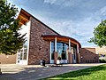
Biblioteka publiczna

Pawilon motyli
Linki zewnętrzne
Przypisy
- ↑ ZIP Code Lookup, Westminster, CO (ang.). United States Postal Service. [dostęp 2014-05-08].
- ↑ U.S. Census Bureau QuickFacts: Westminster city, Colorado; Colorado, www.census.gov [dostęp 2022-02-03] (ang.).
- ↑ US Census Bureau, Decennial Census P.L. 94-171 Redistricting Data, Census.gov [dostęp 2022-02-03].
![]()
Media użyte na tej stronie
Autor: NordNordWest, Licencja: CC BY 3.0
Location map of Colorado, USA
Autor: Uwe Dedering, Licencja: CC BY-SA 3.0
Location map of the USA (without Hawaii and Alaska).
EquiDistantConicProjection:
Central parallel:
* N: 37.0° N
Central meridian:
* E: 96.0° W
Standard parallels:
* 1: 32.0° N
* 2: 42.0° N
Made with Natural Earth. Free vector and raster map data @ naturalearthdata.com.
Formulas for x and y:
x = 50.0 + 124.03149777329222 * ((1.9694462586094064-({{{2}}}* pi / 180))
      * sin(0.6010514667026994 * ({{{3}}} + 96) * pi / 180))
y = 50.0 + 1.6155950752393982 * 124.03149777329222 * 0.02613325650382181
      - 1.6155950752393982  * 124.03149777329222 *
     (1.3236744353715044  - (1.9694462586094064-({{{2}}}* pi / 180))
      * cos(0.6010514667026994 * ({{{3}}} + 96) * pi / 180))

The flag of Navassa Island is simply the United States flag. It does not have a "local" flag or "unofficial" flag; it is an uninhabited island. The version with a profile view was based on Flags of the World and as a fictional design has no status warranting a place on any Wiki. It was made up by a random person with no connection to the island, it has never flown on the island, and it has never received any sort of recognition or validation by any authority. The person quoted on that page has no authority to bestow a flag, "unofficial" or otherwise, on the island.


Autor: Erie Bard, Licencja: CC BY-SA 4.0
The Irving Street branch of the Westminster Public Library. Looking North, with the main entrance on right. Built in 2004.
Houses in northeastern Westminster, Colorado, United States, with the Rocky Mountains in the background. The highest peak on the right side of the picture, underneath the lower of the two clouds, is Longs Peak.

(c) Jpock z angielskiej Wikipedii, CC BY-SA 3.0
The Westminster Castle in Westminster, Colorado near Federal Blvd & W 84th Ave

A flag of the municipality Westminister, in Colorado