Westminster Bridge
| ||
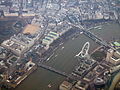
 Tamiza i Westminster Bridge widziane z London Eye | ||
| Państwo | ||
| Miejscowość | Londyn | |
| Podstawowe dane | ||
| Przeszkoda | Tamiza | |
| Data budowy | 1854–1862 | |
| Projektant | Charles Labelye | |
Położenie na mapie Wielkiego Londynu  Contains Ordnance Survey data © Crown copyright and database right, CC BY-SA 3.0 | ||
Położenie na mapie Wielkiej Brytanii  (c) Karte: NordNordWest, Lizenz: Creative Commons by-sa-3.0 de | ||
Położenie na mapie Anglii  | ||
Westminster Bridge – most w Londynie, na Tamizie, między Lambeth Bridge a Hungerford Bridge, wzniesiony w latach 1739–1750, przebudowany w latach 1854–1862; łączy Westminster i Lambeth.
Jak większość mostów na Tamizie służy zarówno pieszym jak i ruchowi samochodowemu. Oryginalny most został zaprojektowany przez Charlesa Labelye i został otwarty 17 listopada 1750. Kolejny most, istniejący w XXI w., został zaprojektowany przez Thomasa Page'a z pomocą Charlesa Barry'ego w 1854 i oficjalnie został oddany do użytku 24 maja 1862[1].
Jego stalowa konstrukcja składa się z siedmiu łuków i jest najstarszą istniejącą konstrukcją mostową w Londynie[2].
 (c) Jared Preston, CC BY-SA 3.0
Mały ruch na moście, mały ruch na rzece.
 (c) Bundesarchiv, Bild 102-12452 / CC-BY-SA 3.0
W momencie dużego ruchu
 (c) Oleg Krivolapov, CC BY-SA 3.0
Miejsca przyciągające turystów
Przypisy
- ↑ Chapter 17 – Westminster Bridge, www.british-history.ac.uk (ang.).
- ↑ Zoe Craig, 11 Secrets Of Westminster Bridge, londonist.com (ang.).
Media użyte na tej stronie
Contains Ordnance Survey data © Crown copyright and database right, CC BY-SA 3.0
Map of Greater London, UK with the following information shown:
- Administrative borders
- Coastline, lakes and rivers
- Roads and railways
- Urban areas
The data includes both primary routes and railway lines.
Equirectangular map projection on WGS 84 datum, with N/S stretched 160%
Geographic limits:
- West: 0.57W
- East: 0.37E
- North: 51.72N
- South: 51.25N
(c) Karte: NordNordWest, Lizenz: Creative Commons by-sa-3.0 de
Location map of the United Kingdom


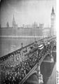
(c) Bundesarchiv, Bild 102-12452 / CC-BY-SA 3.0
Aufziehen der Wachtparade über die grosse Westminster-Brücke in London. Im Hintergrund die weltberühmte Westminster-Abtei.
.jpg)

Autor: Tom Arthur, Licencja: CC BY-SA 2.0
River Thames, Big Ben, and the Palace of Westminster. The bridge nearest the camera is Westminster Bridge, the next bridge is Lambeth Bridge, and bridge just visible in the distance is Vauxhall Bridge (as seen from the London Eye observation wheel.)
