Wijckel
 | |||||
| Państwo | |||||
|---|---|---|---|---|---|
| Prowincja | |||||
| Populacja (2008) • liczba ludności | 700 | ||||
| Kod pocztowy | 8563 | ||||
| Strona internetowa | |||||
Wijckel – wieś położona w północnej Holandii, we Fryzji w gminie Gaasterland-Sloten.
Media użyte na tej stronie
dorpsvlaggen Friesland
(c) Wutsje, CC BY-SA 3.0
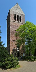
To jest zdjęcie holenderskiego zabytku (rijksmonument) numer 15938
Coat of arms of Gaasterland-Sloten (Netherlands)
Autor: Jan dijkstra, Licencja: CC BY-SA 3.0
De kerk van Wijckel heeft wel een zeer stoere toren ook deze toren is al van heel ver te zien.
Coat of arms of Wikel, Netherlands
Autor: Erik Frohne, Licencja: CC BY-SA 3.0
Location map of province Friesland in the Netherlands
Equirectangular projection, N/S stretching 164 %. Geographic limits of the map:
- N: 53.60° N
- S: 52.60° N
- W: 4.70° E
- E: 6.50° E


