Wyspy Raja Ampat
 | |
| Kontynent | |
|---|---|
| Państwo | |
| Akwen | |
| Liczba wysp | ~1500[1] |
Mapa | |
| 0°14′S 130°31′E/-0,233333 130,516667 | |
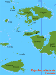
Wyspy Raja Ampat (indonez. Kepulauan Raja Ampat) – archipelag w Indonezji między Morzem Seram i Oceanem Spokojnym, na zachód od półwyspu Ptasia Głowa; administracyjnie wchodzi w skład prowincji Papua Zachodnia, tworząc dystrykt Raja Ampat ze stolicą w Waisai; powierzchnia dystryktu 46 296 km² (wyspy i akwen morski); około 46 tys. mieszkańców (2015); główne wyspy: Waigeo, Misool, Salawati, Batanta.
Od półwyspu Ptasia Głowa oddzielone cieśninami Dampiera i Sele.
Porośnięte lasem równikowym; uprawa ryżu, palmy kokosowej, sagowca; rybołówstwo.
Raja Ampat to idealne miejsce do podziwiania tętniącego życiem oceanu. Archipelag ten uchodzi za jedno z najlepszych miejsc nurkowych na świecie. W 2005 roku Raja Ampat zostało wpisane na listę informacyjną UNESCO[1].
Zobacz też
Przypisy
- ↑ a b Raja Ampat Islands. [w:] Tentative Lists [on-line]. UNESCO. [dostęp 2020-03-04]. (ang.).
Linki zewnętrzne
Media użyte na tej stronie
Autor: Uwe Dedering, Licencja: CC BY-SA 3.0
Location map of Indonesia.
Equirectangular projection. Strechted by 100.0%. Geographic limits of the map:
- N: 6.5° N
- W: 94.5° E
- E: 141.5° E
- S: -11.5° N
bendera Indonesia
Shiny LightSteelBlue button/marker widget. Used to mark the location of something such as a tourist attraction.
Map (rough) of Raja Ampat islands, Indonesia, own work composed from various mapreferences
Autor: Jonathan Chase, Licencja: CC BY 2.5
These Raja Ampat Islands are thought to have the greatest marine diversity on earth. By exploring islands like these in the Malay Archipelago (modern day Indonesia), Alfred Russell Wallace (the “father of biogeography") discovered the Wallace Line and crafted a theory of evolution by natural selection. Biogeography can play a similarly important role in the search for underlying drivers of economic development. doi:10.1371/journal.pbio.1001457.g001


