Yalung Kang
| ||
 | ||
| Państwo | ||
|---|---|---|
| Położenie | Taplejung | |
| Pasmo | Kanczendzonga | |
| Wysokość | 8 505 m n.p.m. | |
| Pierwsze wejście | 14 maja 1973 Yutaka Ageta, Takao Matsuda | |
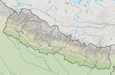
Położenie na mapie Nepalu (c) Karte: NordNordWest, Lizenz: Creative Commons by-sa-3.0 de | ||
Yalung Kang (8505 m n.p.m.) jest drugim pod względem wysokości szczytem w masywie górskim Kanczendzonga, po głównym szczycie. Znany jest także jako zachodni szczyt. Pierwszy raz został zdobyty 14 maja 1973 roku przez Japończyków Yutaka Ageta i Takao Matsuda
Media użyte na tej stronie
The Flag of India. The colours are saffron, white and green. The navy blue wheel in the center of the flag has a diameter approximately the width of the white band and is called Ashoka's Dharma Chakra, with 24 spokes (after Ashoka, the Great). Each spoke depicts one hour of the day, portraying the prevalence of righteousness all 24 hours of it.
Black up-pointing triangle ▲, U+25B2 from Unicode-Block Geometric Shapes (25A0–25FF)
(c) Karte: NordNordWest, Lizenz: Creative Commons by-sa-3.0 de
Location map of Nepal including the 7 provinces
Autor: Carsten.nebel, Licencja: CC BY-SA 3.0
Kachenjunga south face from Nepal


